You are here: Home > Network List > IU - Global Seismograph Network (GSN - IRIS/USGS) Stations List
> Station KNTN Kanton, Kiritibati > Earthquake Result Viewer
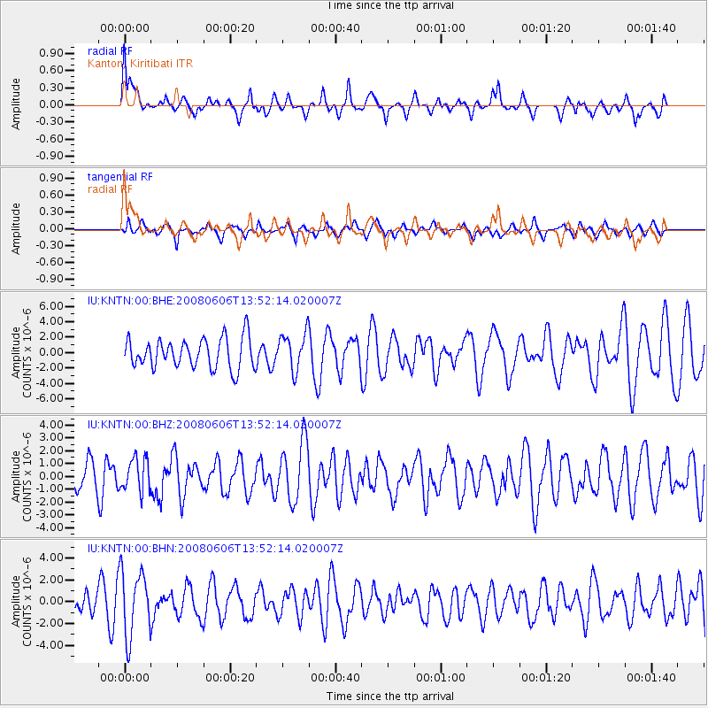
KNTN Kanton, Kiritibati - Earthquake Result Viewer
*The percent match for this event was below the threshold and hence no stack was calculated.
| Earthquake location: |
Banda Sea |
| Earthquake latitude/longitude: |
-7.5/127.9 |
| Earthquake time(UTC): |
2008/06/06 (158) 13:42:48 GMT |
| Earthquake Depth: |
122 km |
| Earthquake Magnitude: |
5.7 MB, 6.0 MW, 6.0 MW |
| Earthquake Catalog/Contributor: |
WHDF/NEIC |
|
| Network: |
IU Global Seismograph Network (GSN - IRIS/USGS) |
| Station: |
KNTN Kanton, Kiritibati |
| Lat/Lon: |
2.77 S/171.72 W |
| Elevation: |
20 m |
|
| Distance: |
60.3 deg |
| Az: |
88.927 deg |
| Baz: |
262.998 deg |
| Ray Param: |
$rayparam |
*The percent match for this event was below the threshold and hence was not used in the summary stack. |
|
| Radial Match: |
59.67437 % |
| Radial Bump: |
400 |
| Transverse Match: |
48.807415 % |
| Transverse Bump: |
361 |
| SOD ConfigId: |
2504 |
| Insert Time: |
2010-03-02 15:51:48.233 +0000 |
| GWidth: |
2.5 |
| Max Bumps: |
400 |
| Tol: |
0.001 |
|
Signal To Noise
| Channel | StoN | STA | LTA |
| IU:KNTN:00:BHZ:20080606T13:52:14.020007Z | 1.0933388 | 1.2844798E-6 | 1.1748232E-6 |
| IU:KNTN:00:BHN:20080606T13:52:14.020007Z | 2.2088807 | 3.0034591E-6 | 1.35972E-6 |
| IU:KNTN:00:BHE:20080606T13:52:14.020007Z | 1.2565113 | 2.4363585E-6 | 1.9389863E-6 |
| Arrivals |
| Ps | |
| PpPs | |
| PsPs/PpSs | |


