You are here: Home > Network List > IU - Global Seismograph Network (GSN - IRIS/USGS) Stations List
> Station KNTN Kanton, Kiritibati > Earthquake Result Viewer
KNTN Kanton, Kiritibati - Earthquake Result Viewer
*The percent match for this event was below the threshold and hence no stack was calculated.
| Earthquake location: |
New Britain Region, P.N.G. |
| Earthquake latitude/longitude: |
-5.9/148.5 |
| Earthquake time(UTC): |
2009/01/22 (022) 13:40:25 GMT |
| Earthquake Depth: |
44 km |
| Earthquake Magnitude: |
5.6 MB, 5.7 MS, 6.1 MW, 6.0 MW |
| Earthquake Catalog/Contributor: |
WHDF/NEIC |
|
| Network: |
IU Global Seismograph Network (GSN - IRIS/USGS) |
| Station: |
KNTN Kanton, Kiritibati |
| Lat/Lon: |
2.77 S/171.72 W |
| Elevation: |
20 m |
|
| Distance: |
39.8 deg |
| Az: |
87.247 deg |
| Baz: |
264.129 deg |
| Ray Param: |
$rayparam |
*The percent match for this event was below the threshold and hence was not used in the summary stack. |
|
| Radial Match: |
62.62461 % |
| Radial Bump: |
400 |
| Transverse Match: |
50.01146 % |
| Transverse Bump: |
400 |
| SOD ConfigId: |
2658 |
| Insert Time: |
2010-03-02 15:52:13.965 +0000 |
| GWidth: |
2.5 |
| Max Bumps: |
400 |
| Tol: |
0.001 |
|
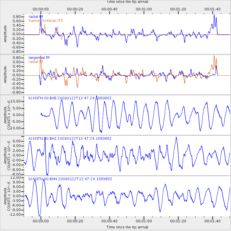
Signal To Noise
| Channel | StoN | STA | LTA |
| IU:KNTN:00:BHZ:20090122T13:47:24.168986Z | 1.8910587 | 4.401853E-6 | 2.327719E-6 |
| IU:KNTN:00:BHN:20090122T13:47:24.168986Z | 2.2343068 | 7.834812E-6 | 3.5065964E-6 |
| IU:KNTN:00:BHE:20090122T13:47:24.168986Z | 1.7107038 | 9.312662E-6 | 5.44376E-6 |
| Arrivals |
| Ps | |
| PpPs | |
| PsPs/PpSs | |


