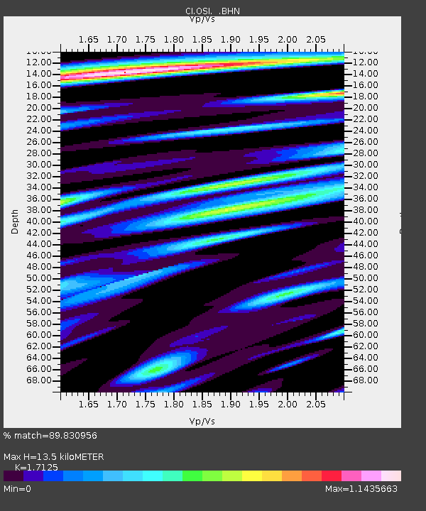
OSI Osito Adit, California, USA - Earthquake Result Viewer

Earthquake location: Near East Coast Of Honshu, Japan
Earthquake latitude/longitude: 38.3/142.0
Earthquake time(UTC): 2005/08/16 (228) 02:46:28 GMT
Earthquake Depth: 36 km
Earthquake Magnitude: 6.5 MB, 6.8 MS, 7.2 MW, 7.1 MW
Earthquake Catalog/Contributor: WHDF/NEIC
Network: CI Caltech Regional Seismic Network
Station: OSI Osito Adit, California, USA
Lat/Lon: 34.61 N/118.72 W
Elevation: 706 m
Distance: 75.8 deg
Az: 57.096 deg
Baz: 306.756 deg
Ray Param: 0.05134276
Estimated Moho Depth: 13.5 km
Estimated Crust Vp/Vs: 1.71
Assumed Crust Vp: 6.1 km/s
Estimated Crust Vs: 3.562 km/s
Estimated Crust Poisson's Ratio: 0.24
Radial Match: 89.830956 %
Radial Bump: 400
Transverse Match: 87.94136 %
Transverse Bump: 400
SOD ConfigId: 2500
Insert Time: 2010-02-25 21:27:18.006 +0000
GWidth: 2.5
Max Bumps: 400
Tol: 0.001

Signal To Noise

ChannelStoNSTALTA
CI:OSI: :BHN:20050816T02:57:39.946997Z1.93638913.0359828E-71.5678579E-7
CI:OSI: :BHE:20050816T02:57:39.946997Z1.57210972.7288786E-71.7358067E-7
CI:OSI: :BHZ:20050816T02:57:39.946997Z3.25255786.0905376E-71.8725379E-7
Arrivals
Ps1.6 SECOND
PpPs5.8 SECOND
PsPs/PpSs7.5 SECOND