You are here: Home > Network List > IU - Global Seismograph Network (GSN - IRIS/USGS) Stations List
> Station XMAS Kiritimati Island, Republic of Kiribati > Earthquake Result Viewer
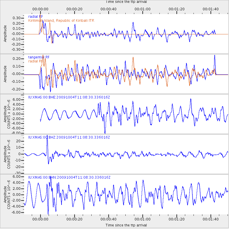
XMAS Kiritimati Island, Republic of Kiribati - Earthquake Result Viewer
*The percent match for this event was below the threshold and hence no stack was calculated.
| Earthquake location: |
Mindanao, Philippines |
| Earthquake latitude/longitude: |
6.7/123.4 |
| Earthquake time(UTC): |
2009/10/04 (277) 10:58:00 GMT |
| Earthquake Depth: |
620 km |
| Earthquake Magnitude: |
6.4 MB, 6.6 MW, 6.6 MW |
| Earthquake Catalog/Contributor: |
WHDF/NEIC |
|
| Network: |
IU Global Seismograph Network (GSN - IRIS/USGS) |
| Station: |
XMAS Kiritimati Island, Republic of Kiribati |
| Lat/Lon: |
2.04 N/157.45 W |
| Elevation: |
20 m |
|
| Distance: |
79.0 deg |
| Az: |
89.223 deg |
| Baz: |
276.428 deg |
| Ray Param: |
$rayparam |
*The percent match for this event was below the threshold and hence was not used in the summary stack. |
|
| Radial Match: |
55.620934 % |
| Radial Bump: |
400 |
| Transverse Match: |
56.705296 % |
| Transverse Bump: |
400 |
| SOD ConfigId: |
1 |
| Insert Time: |
2010-02-19 00:30:45.959 +0000 |
| GWidth: |
2.5 |
| Max Bumps: |
400 |
| Tol: |
0.001 |
|
Signal To Noise
| Channel | StoN | STA | LTA |
| IU:XMAS:00:BHZ:20091004T11:08:30.336016Z | 5.6371346 | 8.846091E-6 | 1.5692532E-6 |
| IU:XMAS:00:BHN:20091004T11:08:30.336016Z | 1.6330855 | 2.5423853E-6 | 1.5567987E-6 |
| IU:XMAS:00:BHE:20091004T11:08:30.336016Z | 1.2626323 | 1.7152895E-6 | 1.3585029E-6 |
| Arrivals |
| Ps | |
| PpPs | |
| PsPs/PpSs | |


