You are here: Home > Network List > TA - USArray Transportable Network (new EarthScope stations) Stations List
> Station G65A Princeton, ME, USA > Earthquake Result Viewer
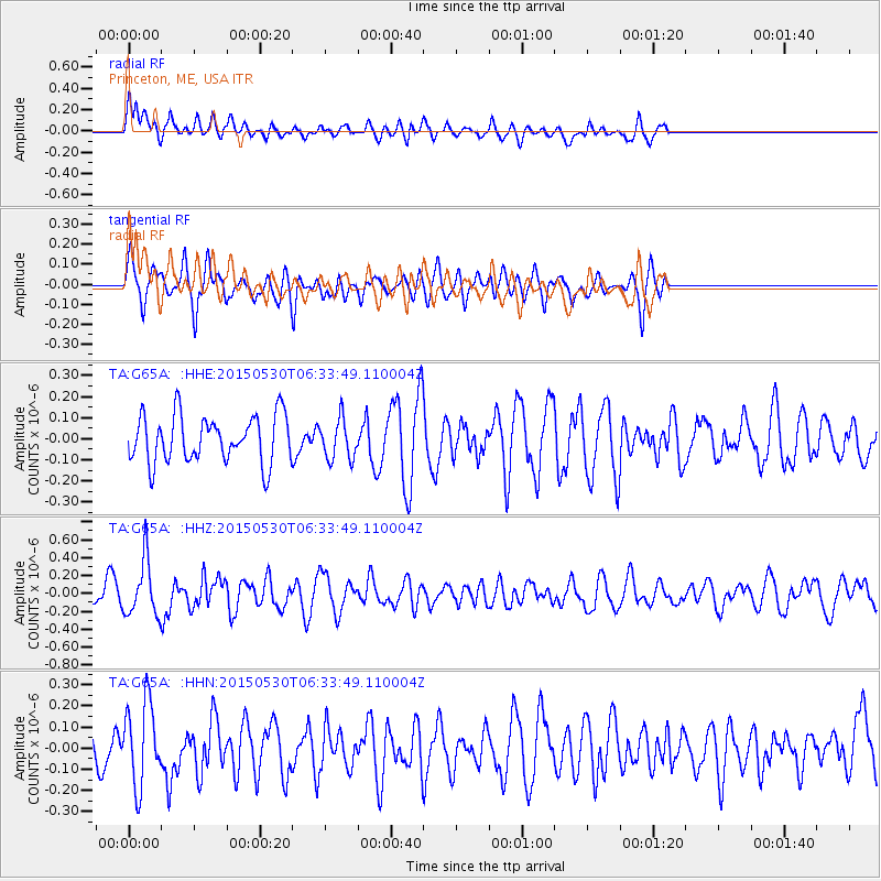
G65A Princeton, ME, USA - Earthquake Result Viewer
*The percent match for this event was below the threshold and hence no stack was calculated.
| Earthquake location: |
Near Coast Of Ecuador |
| Earthquake latitude/longitude: |
1.2/-79.6 |
| Earthquake time(UTC): |
2015/05/30 (150) 06:26:06 GMT |
| Earthquake Depth: |
26 km |
| Earthquake Magnitude: |
5.4 MW, 5.3 mb, 4.8 MS |
| Earthquake Catalog/Contributor: |
ISC/ISC |
|
| Network: |
TA USArray Transportable Network (new EarthScope stations) |
| Station: |
G65A Princeton, ME, USA |
| Lat/Lon: |
45.20 N/67.56 W |
| Elevation: |
78 m |
|
| Distance: |
45.1 deg |
| Az: |
11.991 deg |
| Baz: |
197.085 deg |
| Ray Param: |
$rayparam |
*The percent match for this event was below the threshold and hence was not used in the summary stack. |
|
| Radial Match: |
57.206284 % |
| Radial Bump: |
400 |
| Transverse Match: |
63.419052 % |
| Transverse Bump: |
400 |
| SOD ConfigId: |
7422571 |
| Insert Time: |
2019-04-19 03:04:28.503 +0000 |
| GWidth: |
2.5 |
| Max Bumps: |
400 |
| Tol: |
0.001 |
|
Signal To Noise
| Channel | StoN | STA | LTA |
| TA:G65A: :HHZ:20150530T06:33:49.110004Z | 2.3294544 | 3.0907484E-7 | 1.3268121E-7 |
| TA:G65A: :HHN:20150530T06:33:49.110004Z | 2.0210443 | 1.9417672E-7 | 9.607742E-8 |
| TA:G65A: :HHE:20150530T06:33:49.110004Z | 0.85170996 | 9.479347E-8 | 1.1129784E-7 |
| Arrivals |
| Ps | |
| PpPs | |
| PsPs/PpSs | |


