You are here: Home > Network List > CI - Caltech Regional Seismic Network Stations List
> Station TIN Tinemaha, Big Pine, CA, USA > Earthquake Result Viewer
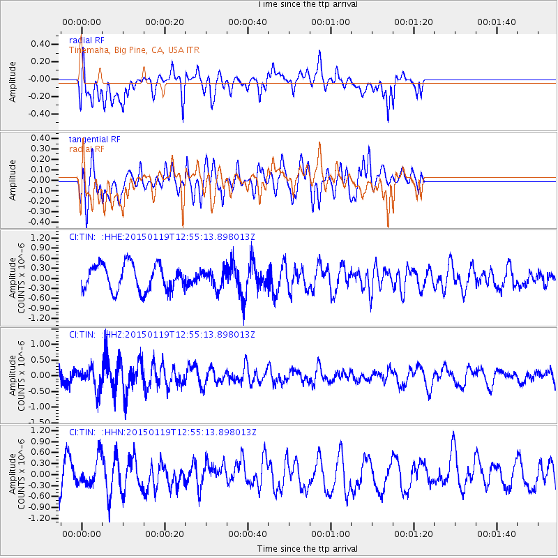
TIN Tinemaha, Big Pine, CA, USA - Earthquake Result Viewer
*The percent match for this event was below the threshold and hence no stack was calculated.
| Earthquake location: |
Greenland Sea |
| Earthquake latitude/longitude: |
73.2/6.4 |
| Earthquake time(UTC): |
2015/01/19 (019) 12:45:13 GMT |
| Earthquake Depth: |
10 km |
| Earthquake Magnitude: |
5.5 MB |
| Earthquake Catalog/Contributor: |
NEIC PDE/NEIC COMCAT |
|
| Network: |
CI Caltech Regional Seismic Network |
| Station: |
TIN Tinemaha, Big Pine, CA, USA |
| Lat/Lon: |
37.05 N/118.23 W |
| Elevation: |
1197 m |
|
| Distance: |
63.8 deg |
| Az: |
312.82 deg |
| Baz: |
15.438 deg |
| Ray Param: |
$rayparam |
*The percent match for this event was below the threshold and hence was not used in the summary stack. |
|
| Radial Match: |
57.296864 % |
| Radial Bump: |
400 |
| Transverse Match: |
56.549232 % |
| Transverse Bump: |
400 |
| SOD ConfigId: |
837871 |
| Insert Time: |
2015-02-02 12:59:32.326 +0000 |
| GWidth: |
2.5 |
| Max Bumps: |
400 |
| Tol: |
0.001 |
|
Signal To Noise
| Channel | StoN | STA | LTA |
| CI:TIN: :HHZ:20150119T12:55:13.898013Z | 1.7945975 | 3.8180698E-7 | 2.1275355E-7 |
| CI:TIN: :HHN:20150119T12:55:13.898013Z | 1.0995325 | 3.7692112E-7 | 3.4280126E-7 |
| CI:TIN: :HHE:20150119T12:55:13.898013Z | 0.70196915 | 2.708208E-7 | 3.858016E-7 |
| Arrivals |
| Ps | |
| PpPs | |
| PsPs/PpSs | |


