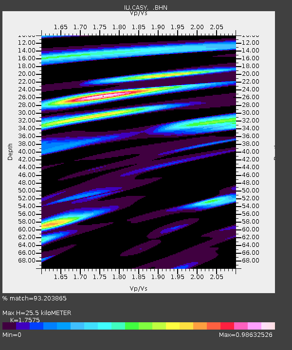
CASY Casey, Antarctica - Earthquake Result Viewer

Earthquake location: Minahassa Peninsula, Sulawesi
Earthquake latitude/longitude: 1.0/120.3
Earthquake time(UTC): 1996/07/16 (198) 10:07:36 GMT
Earthquake Depth: 33 km
Earthquake Magnitude: 6.0 MB, 6.4 MS, 6.6 UNKNOWN, 6.6 MW
Earthquake Catalog/Contributor: WHDF/NEIC
Network: IU Global Seismograph Network (GSN - IRIS/USGS)
Station: CASY Casey, Antarctica
Lat/Lon: 66.28 S/110.54 E
Elevation: 159 m
Distance: 67.5 deg
Az: 184.238 deg
Baz: 10.525 deg
Ray Param: 0.05686047
Estimated Moho Depth: 25.5 km
Estimated Crust Vp/Vs: 1.76
Assumed Crust Vp: 6.356 km/s
Estimated Crust Vs: 3.617 km/s
Estimated Crust Poisson's Ratio: 0.26
Radial Match: 93.203865 %
Radial Bump: 400
Transverse Match: 83.5548 %
Transverse Bump: 400
SOD ConfigId: 6273
Insert Time: 2010-03-02 15:53:37.274 +0000
GWidth: 2.5
Max Bumps: 400
Tol: 0.001

Signal To Noise

ChannelStoNSTALTA
IU:CASY: :BHN:19960716T10:17:58.505029Z14.55577851.6445763E-61.12984424E-7
IU:CASY: :BHE:19960716T10:17:58.505029Z3.2377452.3767691E-77.340816E-8
IU:CASY: :BHZ:19960716T10:17:58.505029Z21.4624143.5097823E-61.6353157E-7
Arrivals
Ps3.2 SECOND
PpPs11 SECOND
PsPs/PpSs14 SECOND