You are here: Home > Network List > AU - Australian Seismological Centre Stations List
> Station CMSA Cobar, New South Wales > Earthquake Result Viewer
CMSA Cobar, New South Wales - Earthquake Result Viewer
| Earthquake location: |
Bonin Islands, Japan Region |
| Earthquake latitude/longitude: |
27.8/140.5 |
| Earthquake time(UTC): |
2015/05/30 (150) 11:23:02 GMT |
| Earthquake Depth: |
678 km |
| Earthquake Magnitude: |
7.8 MWP, 8.5 MI |
| Earthquake Catalog/Contributor: |
NEIC PDE/NEIC COMCAT |
|
| Network: |
AU Australian Seismological Centre |
| Station: |
CMSA Cobar, New South Wales |
| Lat/Lon: |
31.54 S/145.69 E |
| Elevation: |
220 m |
|
| Distance: |
59.2 deg |
| Az: |
174.835 deg |
| Baz: |
354.642 deg |
| Ray Param: |
0.059428204 |
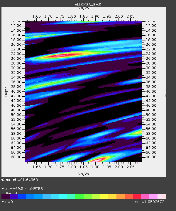
| Estimated Moho Depth: |
69.5 km |
| Estimated Crust Vp/Vs: |
1.90 |
| Assumed Crust Vp: |
6.522 km/s |
| Estimated Crust Vs: |
3.432 km/s |
| Estimated Crust Poisson's Ratio: |
0.31 |
|
| Radial Match: |
91.64968 % |
| Radial Bump: |
400 |
| Transverse Match: |
81.164444 % |
| Transverse Bump: |
400 |
| SOD ConfigId: |
7422571 |
| Insert Time: |
2019-04-19 03:09:09.735 +0000 |
| GWidth: |
2.5 |
| Max Bumps: |
400 |
| Tol: |
0.001 |
|

Signal To Noise
| Channel | StoN | STA | LTA |
| AU:CMSA: :BHZ:20150530T11:31:30.944001Z | 16.405088 | 1.0137661E-5 | 6.179583E-7 |
| AU:CMSA: :BHN:20150530T11:31:30.944001Z | 11.150579 | 5.48081E-6 | 4.91527E-7 |
| AU:CMSA: :BHE:20150530T11:31:30.944001Z | 7.8624625 | 2.4783963E-6 | 3.152188E-7 |
| Arrivals |
| Ps | 10.0 SECOND |
| PpPs | 30 SECOND |
| PsPs/PpSs | 40 SECOND |


