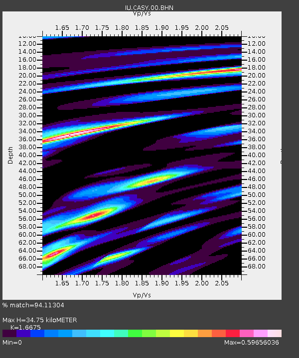
CASY Casey, Antarctica - Earthquake Result Viewer

Earthquake location: Southeast Of Loyalty Islands
Earthquake latitude/longitude: -21.2/169.2
Earthquake time(UTC): 2007/10/13 (286) 17:45:53 GMT
Earthquake Depth: 37 km
Earthquake Magnitude: 5.8 MB, 5.9 MS, 6.1 MW, 6.1 MW
Earthquake Catalog/Contributor: WHDF/NEIC
Network: IU Global Seismograph Network (GSN - IRIS/USGS)
Station: CASY Casey, Antarctica
Lat/Lon: 66.28 S/110.54 E
Elevation: 159 m
Distance: 58.3 deg
Az: 203.962 deg
Baz: 69.486 deg
Ray Param: 0.06286768
Estimated Moho Depth: 34.75 km
Estimated Crust Vp/Vs: 1.67
Assumed Crust Vp: 6.356 km/s
Estimated Crust Vs: 3.812 km/s
Estimated Crust Poisson's Ratio: 0.22
Radial Match: 94.11304 %
Radial Bump: 373
Transverse Match: 85.22217 %
Transverse Bump: 400
SOD ConfigId: 2564
Insert Time: 2010-03-02 15:54:13.419 +0000
GWidth: 2.5
Max Bumps: 400
Tol: 0.001

Signal To Noise

ChannelStoNSTALTA
IU:CASY:00:BHN:20071013T17:55:13.586006Z4.5053132.3467102E-75.2087618E-8
IU:CASY:00:BHE:20071013T17:55:13.586006Z11.1481125.509977E-74.94252E-8
IU:CASY:00:BHZ:20071013T17:55:13.586006Z14.8740481.2680964E-68.5255635E-8
Arrivals
Ps3.8 SECOND
PpPs14 SECOND
PsPs/PpSs18 SECOND