You are here: Home > Network List > IU - Global Seismograph Network (GSN - IRIS/USGS) Stations List
> Station CASY Casey, Antarctica > Earthquake Result Viewer
CASY Casey, Antarctica - Earthquake Result Viewer

| Earthquake location: |
Tonga Islands Region |
| Earthquake latitude/longitude: |
-23.0/-174.7 |
| Earthquake time(UTC): |
2009/03/19 (078) 18:17:40 GMT |
| Earthquake Depth: |
34 km |
| Earthquake Magnitude: |
7.0 MB, 7.6 MS, 7.6 MW, 7.6 MW |
| Earthquake Catalog/Contributor: |
WHDF/NEIC |
|
| Network: |
IU Global Seismograph Network (GSN - IRIS/USGS) |
| Station: |
CASY Casey, Antarctica |
| Lat/Lon: |
66.28 S/110.54 E |
| Elevation: |
159 m |
|
| Distance: |
63.0 deg |
| Az: |
205.981 deg |
| Baz: |
85.925 deg |
| Ray Param: |
0.05978999 |
| Estimated Moho Depth: |
33.75 km |
| Estimated Crust Vp/Vs: |
1.60 |
| Assumed Crust Vp: |
6.356 km/s |
| Estimated Crust Vs: |
3.973 km/s |
| Estimated Crust Poisson's Ratio: |
0.18 |
|
| Radial Match: |
96.34136 % |
| Radial Bump: |
400 |
| Transverse Match: |
85.498886 % |
| Transverse Bump: |
400 |
| SOD ConfigId: |
2658 |
| Insert Time: |
2010-03-02 15:55:08.313 +0000 |
| GWidth: |
2.5 |
| Max Bumps: |
400 |
| Tol: |
0.001 |
|
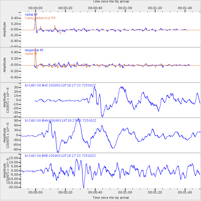
Signal To Noise
| Channel | StoN | STA | LTA |
| IU:CASY:00:BHN:20090319T18:27:33.725002Z | 5.1578665 | 8.991343E-6 | 1.7432291E-6 |
| IU:CASY:00:BHE:20090319T18:27:33.725002Z | 0.8052459 | 8.4159E-7 | 1.0451342E-6 |
| IU:CASY:00:BHZ:20090319T18:27:33.725002Z | 1.8486404 | 2.9122907E-6 | 1.575369E-6 |
| Arrivals |
| Ps | 3.3 SECOND |
| PpPs | 13 SECOND |
| PsPs/PpSs | 17 SECOND |


