You are here: Home > Network List > IU - Global Seismograph Network (GSN - IRIS/USGS) Stations List
> Station CASY Casey, Antarctica > Earthquake Result Viewer
CASY Casey, Antarctica - Earthquake Result Viewer
| Earthquake location: |
Samoa Islands Region |
| Earthquake latitude/longitude: |
-16.6/-172.0 |
| Earthquake time(UTC): |
2006/09/28 (271) 06:22:09 GMT |
| Earthquake Depth: |
28 km |
| Earthquake Magnitude: |
6.5 MB, 6.6 MS, 6.9 MW, 6.7 MW |
| Earthquake Catalog/Contributor: |
WHDF/NEIC |
|
| Network: |
IU Global Seismograph Network (GSN - IRIS/USGS) |
| Station: |
CASY Casey, Antarctica |
| Lat/Lon: |
66.28 S/110.54 E |
| Elevation: |
159 m |
|
| Distance: |
69.9 deg |
| Az: |
204.867 deg |
| Baz: |
85.356 deg |
| Ray Param: |
0.055312917 |
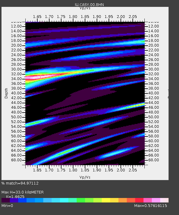
| Estimated Moho Depth: |
33.0 km |
| Estimated Crust Vp/Vs: |
1.66 |
| Assumed Crust Vp: |
6.356 km/s |
| Estimated Crust Vs: |
3.823 km/s |
| Estimated Crust Poisson's Ratio: |
0.22 |
|
| Radial Match: |
94.97112 % |
| Radial Bump: |
284 |
| Transverse Match: |
89.30391 % |
| Transverse Bump: |
391 |
| SOD ConfigId: |
2564 |
| Insert Time: |
2010-03-02 15:55:29.156 +0000 |
| GWidth: |
2.5 |
| Max Bumps: |
400 |
| Tol: |
0.001 |
|

Signal To Noise
| Channel | StoN | STA | LTA |
| IU:CASY:00:BHN:20060928T06:32:46.961018Z | 2.402438 | 5.6070274E-7 | 2.3338907E-7 |
| IU:CASY:00:BHE:20060928T06:32:46.961018Z | 15.793228 | 1.86259E-6 | 1.17936E-7 |
| IU:CASY:00:BHZ:20060928T06:32:46.961018Z | 17.375498 | 4.4835397E-6 | 2.5803806E-7 |
| Arrivals |
| Ps | 3.6 SECOND |
| PpPs | 13 SECOND |
| PsPs/PpSs | 17 SECOND |


