You are here: Home > Network List > KR - Kyrgyz Digital Network Stations List
> Station PRZ Karakol, Kyrgyzstan > Earthquake Result Viewer
PRZ Karakol, Kyrgyzstan - Earthquake Result Viewer
| Earthquake location: |
Bonin Islands, Japan Region |
| Earthquake latitude/longitude: |
27.8/140.5 |
| Earthquake time(UTC): |
2015/05/30 (150) 11:23:02 GMT |
| Earthquake Depth: |
678 km |
| Earthquake Magnitude: |
7.8 MWP, 8.5 MI |
| Earthquake Catalog/Contributor: |
NEIC PDE/NEIC COMCAT |
|
| Network: |
KR Kyrgyz Digital Network |
| Station: |
PRZ Karakol, Kyrgyzstan |
| Lat/Lon: |
42.47 N/78.40 E |
| Elevation: |
1835 m |
|
| Distance: |
51.7 deg |
| Az: |
303.638 deg |
| Baz: |
85.272 deg |
| Ray Param: |
0.06395291 |
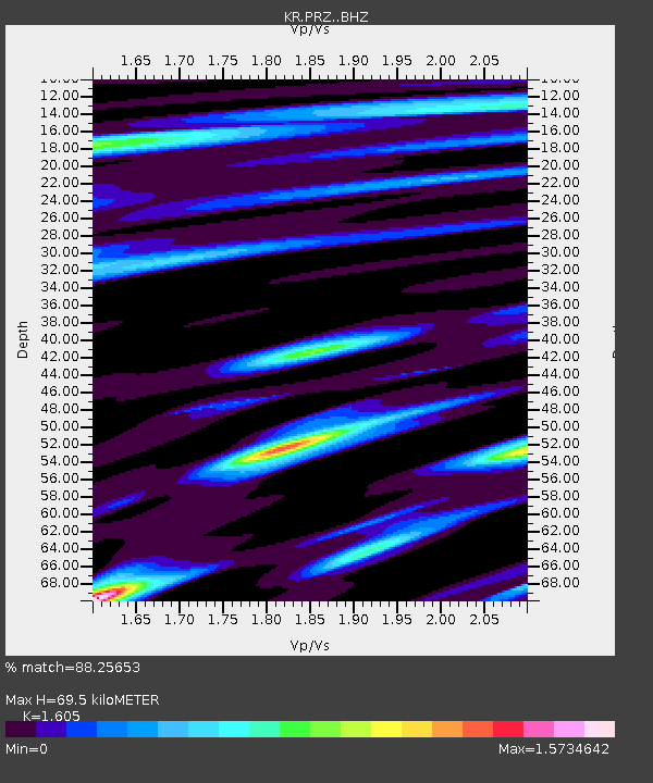
| Estimated Moho Depth: |
69.5 km |
| Estimated Crust Vp/Vs: |
1.61 |
| Assumed Crust Vp: |
6.306 km/s |
| Estimated Crust Vs: |
3.929 km/s |
| Estimated Crust Poisson's Ratio: |
0.18 |
|
| Radial Match: |
88.25653 % |
| Radial Bump: |
400 |
| Transverse Match: |
87.02506 % |
| Transverse Bump: |
400 |
| SOD ConfigId: |
7422571 |
| Insert Time: |
2019-04-19 03:13:38.219 +0000 |
| GWidth: |
2.5 |
| Max Bumps: |
400 |
| Tol: |
0.001 |
|

Signal To Noise
| Channel | StoN | STA | LTA |
| KR:PRZ: :BHZ:20150530T11:30:39.725007Z | 70.77622 | 8.495397E-5 | 1.200318E-6 |
| KR:PRZ: :BHN:20150530T11:30:39.725007Z | 70.52819 | 7.712139E-6 | 1.0934833E-7 |
| KR:PRZ: :BHE:20150530T11:30:39.725007Z | 39.872944 | 3.0344274E-5 | 7.610242E-7 |
| Arrivals |
| Ps | 7.0 SECOND |
| PpPs | 27 SECOND |
| PsPs/PpSs | 34 SECOND |


