You are here: Home > Network List > NI - North-East Italy Broadband Network Stations List
> Station CIMO Cimolais > Earthquake Result Viewer
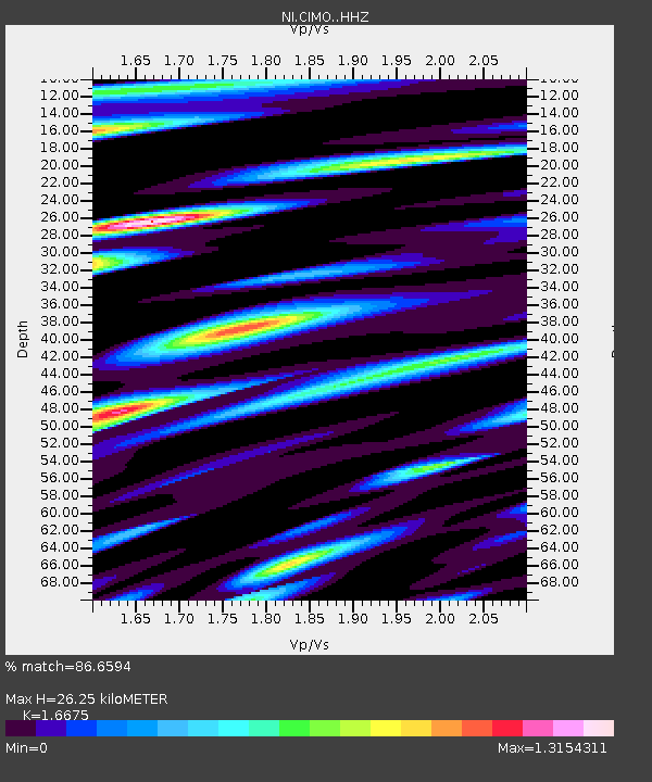
CIMO Cimolais - Earthquake Result Viewer
| Earthquake location: |
Bonin Islands, Japan Region |
| Earthquake latitude/longitude: |
27.8/140.5 |
| Earthquake time(UTC): |
2015/05/30 (150) 11:23:02 GMT |
| Earthquake Depth: |
678 km |
| Earthquake Magnitude: |
7.8 MWP, 8.5 MI |
| Earthquake Catalog/Contributor: |
NEIC PDE/NEIC COMCAT |
|
| Network: |
NI North-East Italy Broadband Network |
| Station: |
CIMO Cimolais |
| Lat/Lon: |
46.31 N/12.44 E |
| Elevation: |
728 m |
|
| Distance: |
92.5 deg |
| Az: |
326.881 deg |
| Baz: |
44.273 deg |
| Ray Param: |
0.040849365 |
| Estimated Moho Depth: |
26.25 km |
| Estimated Crust Vp/Vs: |
1.67 |
| Assumed Crust Vp: |
6.35 km/s |
| Estimated Crust Vs: |
3.808 km/s |
| Estimated Crust Poisson's Ratio: |
0.22 |
|
| Radial Match: |
86.6594 % |
| Radial Bump: |
400 |
| Transverse Match: |
87.85229 % |
| Transverse Bump: |
400 |
| SOD ConfigId: |
7422571 |
| Insert Time: |
2019-04-19 03:14:16.317 +0000 |
| GWidth: |
2.5 |
| Max Bumps: |
400 |
| Tol: |
0.001 |
|

Signal To Noise
| Channel | StoN | STA | LTA |
| NI:CIMO: :HHZ:20150530T11:34:32.238008Z | 44.444454 | 5.1188085E-6 | 1.15173165E-7 |
| NI:CIMO: :HHN:20150530T11:34:32.238008Z | 61.870224 | 2.1701721E-6 | 3.5076198E-8 |
| NI:CIMO: :HHE:20150530T11:34:32.238008Z | 59.23963 | 2.0017605E-6 | 3.37909E-8 |
| Arrivals |
| Ps | 2.8 SECOND |
| PpPs | 11 SECOND |
| PsPs/PpSs | 14 SECOND |


