You are here: Home > Network List > S - Seismographs in Schools Projects Stations List
> Station AUMOU Moura State High School, QLD > Earthquake Result Viewer
AUMOU Moura State High School, QLD - Earthquake Result Viewer
| Earthquake location: |
Bonin Islands, Japan Region |
| Earthquake latitude/longitude: |
27.8/140.5 |
| Earthquake time(UTC): |
2015/05/30 (150) 11:23:02 GMT |
| Earthquake Depth: |
678 km |
| Earthquake Magnitude: |
7.8 MWP, 8.5 MI |
| Earthquake Catalog/Contributor: |
NEIC PDE/NEIC COMCAT |
|
| Network: |
S Seismographs in Schools Projects |
| Station: |
AUMOU Moura State High School, QLD |
| Lat/Lon: |
24.58 S/149.98 E |
| Elevation: |
153 m |
|
| Distance: |
52.9 deg |
| Az: |
169.154 deg |
| Baz: |
349.453 deg |
| Ray Param: |
0.06326774 |
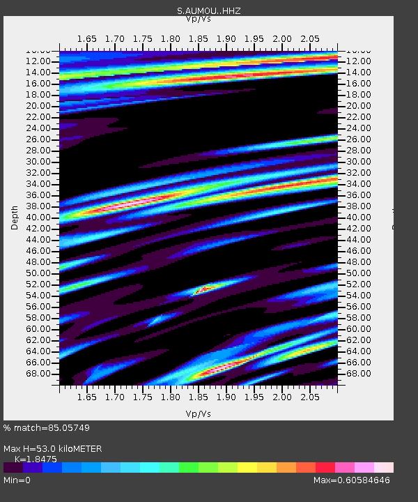
| Estimated Moho Depth: |
53.0 km |
| Estimated Crust Vp/Vs: |
1.85 |
| Assumed Crust Vp: |
6.316 km/s |
| Estimated Crust Vs: |
3.419 km/s |
| Estimated Crust Poisson's Ratio: |
0.29 |
|
| Radial Match: |
85.05749 % |
| Radial Bump: |
400 |
| Transverse Match: |
67.11894 % |
| Transverse Bump: |
400 |
| SOD ConfigId: |
7422571 |
| Insert Time: |
2019-04-19 03:15:56.530 +0000 |
| GWidth: |
2.5 |
| Max Bumps: |
400 |
| Tol: |
0.001 |
|

Signal To Noise
| Channel | StoN | STA | LTA |
| S:AUMOU: :HHZ:20150530T11:30:47.799989Z | 31.770664 | 1.3666581E-5 | 4.301635E-7 |
| S:AUMOU: :HHN:20150530T11:30:47.799989Z | 5.073896 | 4.0494947E-6 | 7.981036E-7 |
| S:AUMOU: :HHE:20150530T11:30:47.799989Z | 2.549578 | 1.6385212E-6 | 6.4266374E-7 |
| Arrivals |
| Ps | 7.4 SECOND |
| PpPs | 23 SECOND |
| PsPs/PpSs | 30 SECOND |


