You are here: Home > Network List > S - Seismographs in Schools Projects Stations List
> Station AUMTS Mt Stromlo, ANU > Earthquake Result Viewer
AUMTS Mt Stromlo, ANU - Earthquake Result Viewer
| Earthquake location: |
Bonin Islands, Japan Region |
| Earthquake latitude/longitude: |
27.8/140.5 |
| Earthquake time(UTC): |
2015/05/30 (150) 11:23:02 GMT |
| Earthquake Depth: |
678 km |
| Earthquake Magnitude: |
7.8 MWP, 8.5 MI |
| Earthquake Catalog/Contributor: |
NEIC PDE/NEIC COMCAT |
|
| Network: |
S Seismographs in Schools Projects |
| Station: |
AUMTS Mt Stromlo, ANU |
| Lat/Lon: |
35.32 S/149.00 E |
| Elevation: |
667 m |
|
| Distance: |
63.3 deg |
| Az: |
172.222 deg |
| Baz: |
351.573 deg |
| Ray Param: |
0.05693748 |
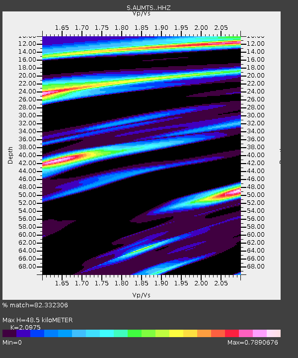
| Estimated Moho Depth: |
48.5 km |
| Estimated Crust Vp/Vs: |
2.10 |
| Assumed Crust Vp: |
6.633 km/s |
| Estimated Crust Vs: |
3.162 km/s |
| Estimated Crust Poisson's Ratio: |
0.35 |
|
| Radial Match: |
82.332306 % |
| Radial Bump: |
373 |
| Transverse Match: |
70.96332 % |
| Transverse Bump: |
400 |
| SOD ConfigId: |
7422571 |
| Insert Time: |
2019-04-19 03:15:57.962 +0000 |
| GWidth: |
2.5 |
| Max Bumps: |
400 |
| Tol: |
0.001 |
|

Signal To Noise
| Channel | StoN | STA | LTA |
| S:AUMTS: :HHZ:20150530T11:31:57.189973Z | 21.836811 | 1.494081E-5 | 6.842029E-7 |
| S:AUMTS: :HHN:20150530T11:31:57.189973Z | 11.401997 | 6.549309E-6 | 5.744002E-7 |
| S:AUMTS: :HHE:20150530T11:31:57.189973Z | 3.1609495 | 1.9584368E-6 | 6.1957235E-7 |
| Arrivals |
| Ps | 8.3 SECOND |
| PpPs | 22 SECOND |
| PsPs/PpSs | 30 SECOND |


