You are here: Home > Network List > TA - USArray Transportable Network (new EarthScope stations) Stations List
> Station A04D Lummi Island, WA, USA > Earthquake Result Viewer
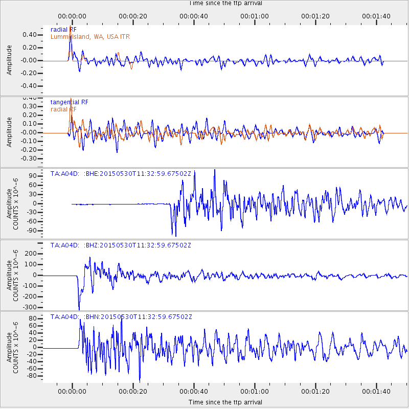
A04D Lummi Island, WA, USA - Earthquake Result Viewer
*The percent match for this event was below the threshold and hence no stack was calculated.
| Earthquake location: |
Bonin Islands, Japan Region |
| Earthquake latitude/longitude: |
27.8/140.5 |
| Earthquake time(UTC): |
2015/05/30 (150) 11:23:02 GMT |
| Earthquake Depth: |
678 km |
| Earthquake Magnitude: |
7.8 MWP, 8.5 MI |
| Earthquake Catalog/Contributor: |
NEIC PDE/NEIC COMCAT |
|
| Network: |
TA USArray Transportable Network (new EarthScope stations) |
| Station: |
A04D Lummi Island, WA, USA |
| Lat/Lon: |
48.72 N/122.71 W |
| Elevation: |
13 m |
|
| Distance: |
73.8 deg |
| Az: |
43.21 deg |
| Baz: |
293.706 deg |
| Ray Param: |
$rayparam |
*The percent match for this event was below the threshold and hence was not used in the summary stack. |
|
| Radial Match: |
88.458 % |
| Radial Bump: |
400 |
| Transverse Match: |
87.4239 % |
| Transverse Bump: |
400 |
| SOD ConfigId: |
7422571 |
| Insert Time: |
2019-04-19 03:16:20.009 +0000 |
| GWidth: |
2.5 |
| Max Bumps: |
400 |
| Tol: |
0.001 |
|
Signal To Noise
| Channel | StoN | STA | LTA |
| TA:A04D: :BHZ:20150530T11:32:59.67502Z | 82.2104 | 1.1456302E-4 | 1.3935343E-6 |
| TA:A04D: :BHN:20150530T11:32:59.67502Z | 93.57368 | 3.0154282E-5 | 3.2225176E-7 |
| TA:A04D: :BHE:20150530T11:32:59.67502Z | 56.334835 | 3.5569585E-5 | 6.3139595E-7 |
| Arrivals |
| Ps | |
| PpPs | |
| PsPs/PpSs | |


