You are here: Home > Network List > TA - USArray Transportable Network (new EarthScope stations) Stations List
> Station K02D Willamette Meridian, OR, USA > Earthquake Result Viewer
K02D Willamette Meridian, OR, USA - Earthquake Result Viewer

| Earthquake location: |
Bonin Islands, Japan Region |
| Earthquake latitude/longitude: |
27.8/140.5 |
| Earthquake time(UTC): |
2015/05/30 (150) 11:23:02 GMT |
| Earthquake Depth: |
678 km |
| Earthquake Magnitude: |
7.8 MWP, 8.5 MI |
| Earthquake Catalog/Contributor: |
NEIC PDE/NEIC COMCAT |
|
| Network: |
TA USArray Transportable Network (new EarthScope stations) |
| Station: |
K02D Willamette Meridian, OR, USA |
| Lat/Lon: |
42.70 N/123.67 W |
| Elevation: |
989 m |
|
| Distance: |
75.7 deg |
| Az: |
49.194 deg |
| Baz: |
294.596 deg |
| Ray Param: |
0.049214073 |
| Estimated Moho Depth: |
19.75 km |
| Estimated Crust Vp/Vs: |
2.05 |
| Assumed Crust Vp: |
6.522 km/s |
| Estimated Crust Vs: |
3.185 km/s |
| Estimated Crust Poisson's Ratio: |
0.34 |
|
| Radial Match: |
90.664085 % |
| Radial Bump: |
400 |
| Transverse Match: |
91.85237 % |
| Transverse Bump: |
400 |
| SOD ConfigId: |
7422571 |
| Insert Time: |
2019-04-19 03:16:41.394 +0000 |
| GWidth: |
2.5 |
| Max Bumps: |
400 |
| Tol: |
0.001 |
|
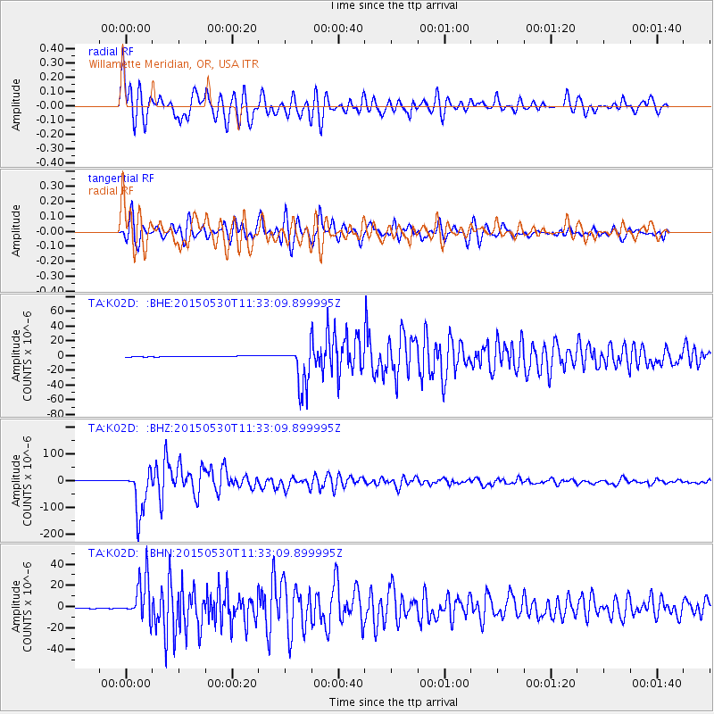
Signal To Noise
| Channel | StoN | STA | LTA |
| TA:K02D: :BHZ:20150530T11:33:09.899995Z | 62.586628 | 8.435634E-5 | 1.3478333E-6 |
| TA:K02D: :BHN:20150530T11:33:09.899995Z | 66.42383 | 1.9454801E-5 | 2.9288887E-7 |
| TA:K02D: :BHE:20150530T11:33:09.899995Z | 59.04203 | 3.114094E-5 | 5.274368E-7 |
| Arrivals |
| Ps | 3.3 SECOND |
| PpPs | 9.0 SECOND |
| PsPs/PpSs | 12 SECOND |


