You are here: Home > Network List > TA - USArray Transportable Network (new EarthScope stations) Stations List
> Station K27K Chicken, AK, USA > Earthquake Result Viewer
K27K Chicken, AK, USA - Earthquake Result Viewer
| Earthquake location: |
Bonin Islands, Japan Region |
| Earthquake latitude/longitude: |
27.8/140.5 |
| Earthquake time(UTC): |
2015/05/30 (150) 11:23:02 GMT |
| Earthquake Depth: |
678 km |
| Earthquake Magnitude: |
7.8 MWP, 8.5 MI |
| Earthquake Catalog/Contributor: |
NEIC PDE/NEIC COMCAT |
|
| Network: |
TA USArray Transportable Network (new EarthScope stations) |
| Station: |
K27K Chicken, AK, USA |
| Lat/Lon: |
64.03 N/142.08 W |
| Elevation: |
389 m |
|
| Distance: |
59.9 deg |
| Az: |
29.791 deg |
| Baz: |
272.083 deg |
| Ray Param: |
0.05903884 |
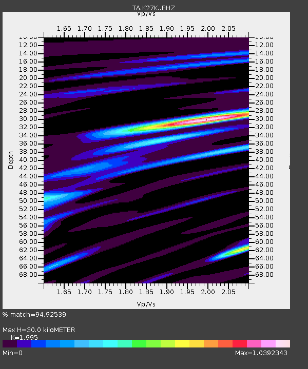
| Estimated Moho Depth: |
30.0 km |
| Estimated Crust Vp/Vs: |
2.00 |
| Assumed Crust Vp: |
6.566 km/s |
| Estimated Crust Vs: |
3.291 km/s |
| Estimated Crust Poisson's Ratio: |
0.33 |
|
| Radial Match: |
94.92539 % |
| Radial Bump: |
400 |
| Transverse Match: |
78.58004 % |
| Transverse Bump: |
400 |
| SOD ConfigId: |
7422571 |
| Insert Time: |
2019-04-19 03:16:44.927 +0000 |
| GWidth: |
2.5 |
| Max Bumps: |
400 |
| Tol: |
0.001 |
|

Signal To Noise
| Channel | StoN | STA | LTA |
| TA:K27K: :BHZ:20150530T11:31:35.124971Z | 116.4243 | 1.12641355E-4 | 9.675072E-7 |
| TA:K27K: :BHN:20150530T11:31:35.124971Z | 221.90765 | 1.4281294E-5 | 6.4356925E-8 |
| TA:K27K: :BHE:20150530T11:31:35.124971Z | 93.96651 | 5.8128062E-5 | 6.186041E-7 |
| Arrivals |
| Ps | 4.7 SECOND |
| PpPs | 13 SECOND |
| PsPs/PpSs | 18 SECOND |


