You are here: Home > Network List > TA - USArray Transportable Network (new EarthScope stations) Stations List
> Station S22A 4UR Ranch, Creede, CO, USA > Earthquake Result Viewer
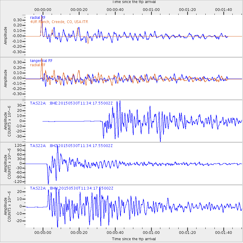
S22A 4UR Ranch, Creede, CO, USA - Earthquake Result Viewer
| Earthquake location: |
Bonin Islands, Japan Region |
| Earthquake latitude/longitude: |
27.8/140.5 |
| Earthquake time(UTC): |
2015/05/30 (150) 11:23:02 GMT |
| Earthquake Depth: |
678 km |
| Earthquake Magnitude: |
7.8 MWP, 8.5 MI |
| Earthquake Catalog/Contributor: |
NEIC PDE/NEIC COMCAT |
|
| Network: |
TA USArray Transportable Network (new EarthScope stations) |
| Station: |
S22A 4UR Ranch, Creede, CO, USA |
| Lat/Lon: |
37.75 N/106.83 W |
| Elevation: |
2626 m |
|
| Distance: |
89.3 deg |
| Az: |
47.011 deg |
| Baz: |
305.193 deg |
| Ray Param: |
0.041520484 |
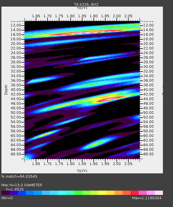
| Estimated Moho Depth: |
15.0 km |
| Estimated Crust Vp/Vs: |
1.85 |
| Assumed Crust Vp: |
6.159 km/s |
| Estimated Crust Vs: |
3.325 km/s |
| Estimated Crust Poisson's Ratio: |
0.29 |
|
| Radial Match: |
94.83545 % |
| Radial Bump: |
400 |
| Transverse Match: |
90.31043 % |
| Transverse Bump: |
400 |
| SOD ConfigId: |
7422571 |
| Insert Time: |
2019-04-19 03:16:59.579 +0000 |
| GWidth: |
2.5 |
| Max Bumps: |
400 |
| Tol: |
0.001 |
|
Signal To Noise
| Channel | StoN | STA | LTA |
| TA:S22A: :BHZ:20150530T11:34:17.55002Z | 74.09592 | 4.432323E-5 | 5.981872E-7 |
| TA:S22A: :BHN:20150530T11:34:17.55002Z | 55.583572 | 8.925954E-6 | 1.6058617E-7 |
| TA:S22A: :BHE:20150530T11:34:17.55002Z | 44.025074 | 1.0139736E-5 | 2.303173E-7 |
| Arrivals |
| Ps | 2.1 SECOND |
| PpPs | 6.8 SECOND |
| PsPs/PpSs | 8.9 SECOND |


