You are here: Home > Network List > TA - USArray Transportable Network (new EarthScope stations) Stations List
> Station T25A Trinidad, CO, USA > Earthquake Result Viewer
T25A Trinidad, CO, USA - Earthquake Result Viewer

| Earthquake location: |
Bonin Islands, Japan Region |
| Earthquake latitude/longitude: |
27.8/140.5 |
| Earthquake time(UTC): |
2015/05/30 (150) 11:23:02 GMT |
| Earthquake Depth: |
678 km |
| Earthquake Magnitude: |
7.8 MWP, 8.5 MI |
| Earthquake Catalog/Contributor: |
NEIC PDE/NEIC COMCAT |
|
| Network: |
TA USArray Transportable Network (new EarthScope stations) |
| Station: |
T25A Trinidad, CO, USA |
| Lat/Lon: |
37.14 N/104.41 W |
| Elevation: |
2017 m |
|
| Distance: |
91.2 deg |
| Az: |
46.373 deg |
| Baz: |
306.66 deg |
| Ray Param: |
0.04116481 |
| Estimated Moho Depth: |
41.5 km |
| Estimated Crust Vp/Vs: |
1.80 |
| Assumed Crust Vp: |
6.316 km/s |
| Estimated Crust Vs: |
3.504 km/s |
| Estimated Crust Poisson's Ratio: |
0.28 |
|
| Radial Match: |
96.550835 % |
| Radial Bump: |
400 |
| Transverse Match: |
96.319405 % |
| Transverse Bump: |
400 |
| SOD ConfigId: |
7422571 |
| Insert Time: |
2019-04-19 03:17:01.564 +0000 |
| GWidth: |
2.5 |
| Max Bumps: |
400 |
| Tol: |
0.001 |
|
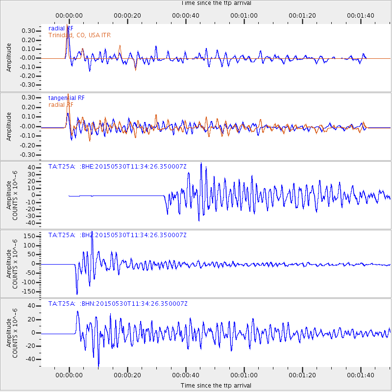
Signal To Noise
| Channel | StoN | STA | LTA |
| TA:T25A: :BHZ:20150530T11:34:26.350007Z | 89.495926 | 4.948242E-5 | 5.529014E-7 |
| TA:T25A: :BHN:20150530T11:34:26.350007Z | 72.696335 | 1.1954406E-5 | 1.6444304E-7 |
| TA:T25A: :BHE:20150530T11:34:26.350007Z | 42.872654 | 8.30633E-6 | 1.9374424E-7 |
| Arrivals |
| Ps | 5.4 SECOND |
| PpPs | 18 SECOND |
| PsPs/PpSs | 23 SECOND |


