You are here: Home > Network List > TJ - Tajikistan National Seismic Network Stations List
> Station GARM Garm, Tajikistan > Earthquake Result Viewer
GARM Garm, Tajikistan - Earthquake Result Viewer
| Earthquake location: |
Bonin Islands, Japan Region |
| Earthquake latitude/longitude: |
27.8/140.5 |
| Earthquake time(UTC): |
2015/05/30 (150) 11:23:02 GMT |
| Earthquake Depth: |
678 km |
| Earthquake Magnitude: |
7.8 MWP, 8.5 MI |
| Earthquake Catalog/Contributor: |
NEIC PDE/NEIC COMCAT |
|
| Network: |
TJ Tajikistan National Seismic Network |
| Station: |
GARM Garm, Tajikistan |
| Lat/Lon: |
39.00 N/70.32 E |
| Elevation: |
1305 m |
|
| Distance: |
58.3 deg |
| Az: |
300.533 deg |
| Baz: |
78.227 deg |
| Ray Param: |
0.05998299 |
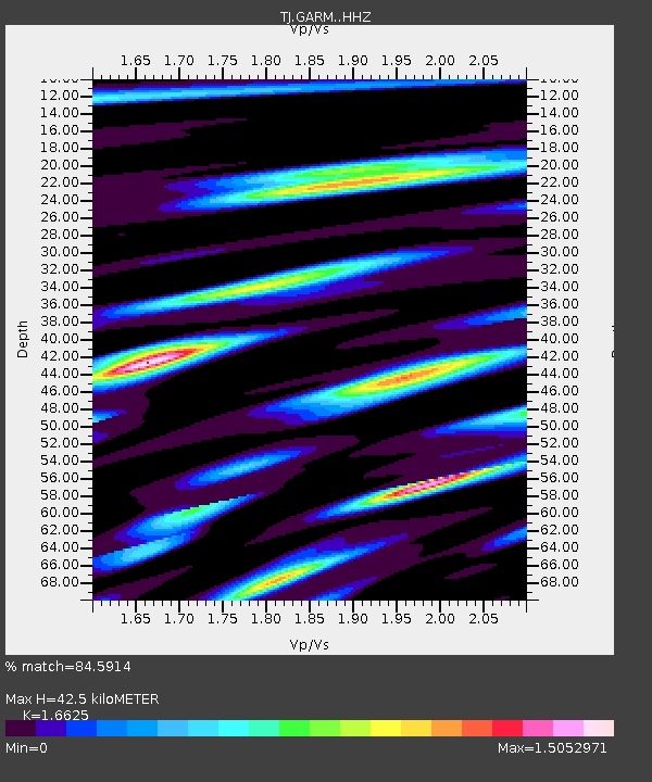
| Estimated Moho Depth: |
42.5 km |
| Estimated Crust Vp/Vs: |
1.66 |
| Assumed Crust Vp: |
6.306 km/s |
| Estimated Crust Vs: |
3.793 km/s |
| Estimated Crust Poisson's Ratio: |
0.22 |
|
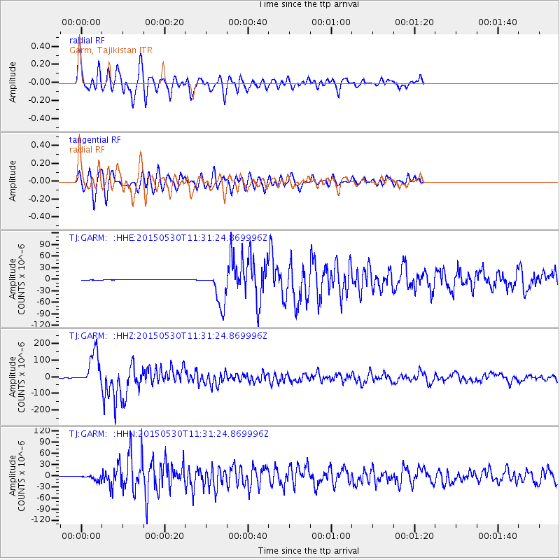
| Radial Match: |
84.5914 % |
| Radial Bump: |
400 |
| Transverse Match: |
78.19318 % |
| Transverse Bump: |
400 |
| SOD ConfigId: |
7422571 |
| Insert Time: |
2019-04-19 03:17:13.257 +0000 |
| GWidth: |
2.5 |
| Max Bumps: |
400 |
| Tol: |
0.001 |
|
Signal To Noise
| Channel | StoN | STA | LTA |
| TJ:GARM: :HHZ:20150530T11:31:24.869996Z | 423.58157 | 1.0364269E-4 | 2.446818E-7 |
| TJ:GARM: :HHN:20150530T11:31:24.869996Z | 91.60105 | 7.0737046E-6 | 7.7222964E-8 |
| TJ:GARM: :HHE:20150530T11:31:24.869996Z | 265.6348 | 4.708947E-5 | 1.7727147E-7 |
| Arrivals |
| Ps | 4.7 SECOND |
| PpPs | 17 SECOND |
| PsPs/PpSs | 22 SECOND |


