You are here: Home > Network List > TJ - Tajikistan National Seismic Network Stations List
> Station MANEM Manem, Tajikistan > Earthquake Result Viewer
MANEM Manem, Tajikistan - Earthquake Result Viewer
| Earthquake location: |
Bonin Islands, Japan Region |
| Earthquake latitude/longitude: |
27.8/140.5 |
| Earthquake time(UTC): |
2015/05/30 (150) 11:23:02 GMT |
| Earthquake Depth: |
678 km |
| Earthquake Magnitude: |
7.8 MWP, 8.5 MI |
| Earthquake Catalog/Contributor: |
NEIC PDE/NEIC COMCAT |
|
| Network: |
TJ Tajikistan National Seismic Network |
| Station: |
MANEM Manem, Tajikistan |
| Lat/Lon: |
37.53 N/71.66 E |
| Elevation: |
2312 m |
|
| Distance: |
57.6 deg |
| Az: |
298.582 deg |
| Baz: |
78.02 deg |
| Ray Param: |
0.06043016 |
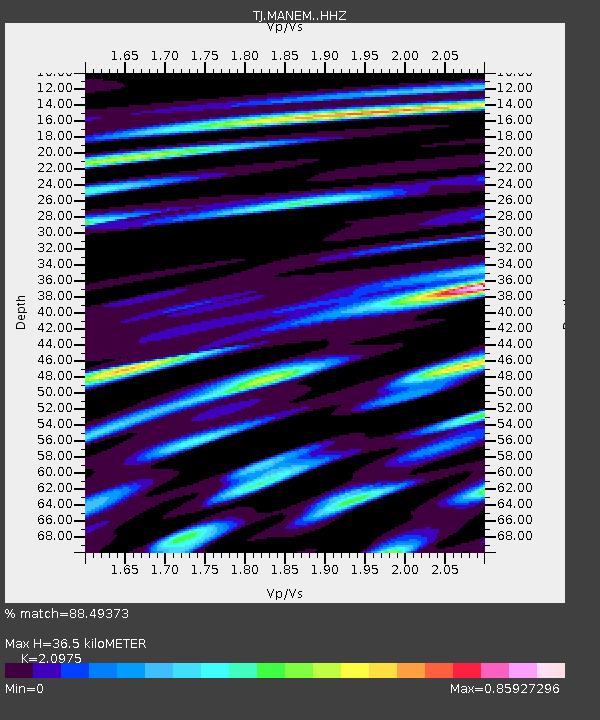
| Estimated Moho Depth: |
36.5 km |
| Estimated Crust Vp/Vs: |
2.10 |
| Assumed Crust Vp: |
6.306 km/s |
| Estimated Crust Vs: |
3.006 km/s |
| Estimated Crust Poisson's Ratio: |
0.35 |
|
| Radial Match: |
88.49373 % |
| Radial Bump: |
400 |
| Transverse Match: |
76.52423 % |
| Transverse Bump: |
400 |
| SOD ConfigId: |
7422571 |
| Insert Time: |
2019-04-19 03:17:14.036 +0000 |
| GWidth: |
2.5 |
| Max Bumps: |
400 |
| Tol: |
0.001 |
|

Signal To Noise
| Channel | StoN | STA | LTA |
| TJ:MANEM: :HHZ:20150530T11:31:19.980012Z | 259.35175 | 1.2083465E-4 | 4.6591032E-7 |
| TJ:MANEM: :HHN:20150530T11:31:19.980012Z | 165.5876 | 1.6394917E-5 | 9.901053E-8 |
| TJ:MANEM: :HHE:20150530T11:31:19.980012Z | 150.11894 | 4.599715E-5 | 3.064047E-7 |
| Arrivals |
| Ps | 6.6 SECOND |
| PpPs | 17 SECOND |
| PsPs/PpSs | 24 SECOND |


