You are here: Home > Network List > TM - Thai Seismic Monitoring Network Stations List
> Station LOEI LOEI staion > Earthquake Result Viewer
LOEI LOEI staion - Earthquake Result Viewer
| Earthquake location: |
Bonin Islands, Japan Region |
| Earthquake latitude/longitude: |
27.8/140.5 |
| Earthquake time(UTC): |
2015/05/30 (150) 11:23:02 GMT |
| Earthquake Depth: |
678 km |
| Earthquake Magnitude: |
7.8 MWP, 8.5 MI |
| Earthquake Catalog/Contributor: |
NEIC PDE/NEIC COMCAT |
|
| Network: |
TM Thai Seismic Monitoring Network |
| Station: |
LOEI LOEI staion |
| Lat/Lon: |
17.51 N/101.62 E |
| Elevation: |
305 m |
|
| Distance: |
37.2 deg |
| Az: |
262.37 deg |
| Baz: |
66.906 deg |
| Ray Param: |
0.07250595 |
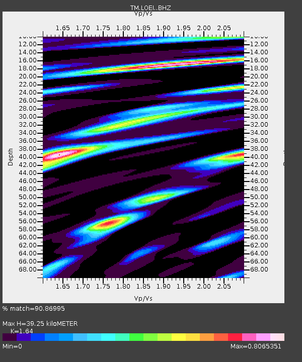
| Estimated Moho Depth: |
39.25 km |
| Estimated Crust Vp/Vs: |
1.64 |
| Assumed Crust Vp: |
6.35 km/s |
| Estimated Crust Vs: |
3.872 km/s |
| Estimated Crust Poisson's Ratio: |
0.20 |
|
| Radial Match: |
90.86995 % |
| Radial Bump: |
400 |
| Transverse Match: |
90.4032 % |
| Transverse Bump: |
400 |
| SOD ConfigId: |
7422571 |
| Insert Time: |
2019-04-19 03:17:18.752 +0000 |
| GWidth: |
2.5 |
| Max Bumps: |
400 |
| Tol: |
0.001 |
|

Signal To Noise
| Channel | StoN | STA | LTA |
| TM:LOEI: :BHZ:20150530T11:28:49.399995Z | 124.467766 | 1.7544809E-4 | 1.4095865E-6 |
| TM:LOEI: :BHN:20150530T11:28:49.399995Z | 0.20884919 | 4.6813378E-7 | 2.241492E-6 |
| TM:LOEI: :BHE:20150530T11:28:49.399995Z | 51.365685 | 6.01671E-5 | 1.1713481E-6 |
| Arrivals |
| Ps | 4.2 SECOND |
| PpPs | 15 SECOND |
| PsPs/PpSs | 19 SECOND |


