You are here: Home > Network List > UW - Pacific Northwest Regional Seismic Network Stations List
> Station CCRK Sunnyside, WA, USA > Earthquake Result Viewer
CCRK Sunnyside, WA, USA - Earthquake Result Viewer
| Earthquake location: |
Bonin Islands, Japan Region |
| Earthquake latitude/longitude: |
27.8/140.5 |
| Earthquake time(UTC): |
2015/05/30 (150) 11:23:02 GMT |
| Earthquake Depth: |
678 km |
| Earthquake Magnitude: |
7.8 MWP, 8.5 MI |
| Earthquake Catalog/Contributor: |
NEIC PDE/NEIC COMCAT |
|
| Network: |
UW Pacific Northwest Regional Seismic Network |
| Station: |
CCRK Sunnyside, WA, USA |
| Lat/Lon: |
46.56 N/119.85 W |
| Elevation: |
561 m |
|
| Distance: |
76.5 deg |
| Az: |
44.399 deg |
| Baz: |
296.112 deg |
| Ray Param: |
0.0486934 |
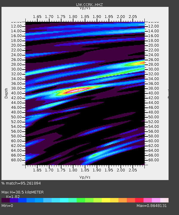
| Estimated Moho Depth: |
38.5 km |
| Estimated Crust Vp/Vs: |
1.82 |
| Assumed Crust Vp: |
6.419 km/s |
| Estimated Crust Vs: |
3.527 km/s |
| Estimated Crust Poisson's Ratio: |
0.28 |
|
| Radial Match: |
95.261894 % |
| Radial Bump: |
400 |
| Transverse Match: |
89.396194 % |
| Transverse Bump: |
400 |
| SOD ConfigId: |
7422571 |
| Insert Time: |
2019-04-19 03:18:05.218 +0000 |
| GWidth: |
2.5 |
| Max Bumps: |
400 |
| Tol: |
0.001 |
|

Signal To Noise
| Channel | StoN | STA | LTA |
| UW:CCRK: :HHZ:20150530T11:33:14.277986Z | 124.22728 | 1.0786427E-4 | 8.682817E-7 |
| UW:CCRK: :HHN:20150530T11:33:14.277986Z | 83.97804 | 1.9497631E-5 | 2.3217535E-7 |
| UW:CCRK: :HHE:20150530T11:33:14.277986Z | 88.73131 | 3.544374E-5 | 3.9945022E-7 |
| Arrivals |
| Ps | 5.1 SECOND |
| PpPs | 16 SECOND |
| PsPs/PpSs | 22 SECOND |


