You are here: Home > Network List > UW - Pacific Northwest Regional Seismic Network Stations List
> Station HEBO Mt. Hebo, OR CREST BB SMO > Earthquake Result Viewer
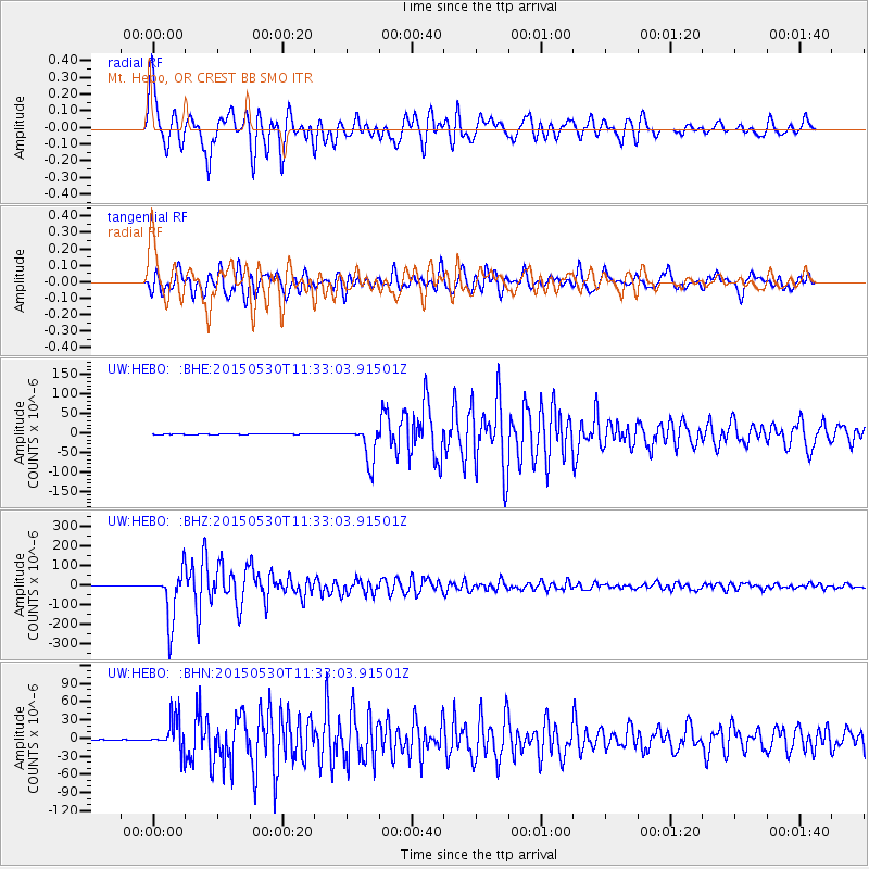
HEBO Mt. Hebo, OR CREST BB SMO - Earthquake Result Viewer

| Earthquake location: |
Bonin Islands, Japan Region |
| Earthquake latitude/longitude: |
27.8/140.5 |
| Earthquake time(UTC): |
2015/05/30 (150) 11:23:02 GMT |
| Earthquake Depth: |
678 km |
| Earthquake Magnitude: |
7.8 MWP, 8.5 MI |
| Earthquake Catalog/Contributor: |
NEIC PDE/NEIC COMCAT |
|
| Network: |
UW Pacific Northwest Regional Seismic Network |
| Station: |
HEBO Mt. Hebo, OR CREST BB SMO |
| Lat/Lon: |
45.21 N/123.76 W |
| Elevation: |
875 m |
|
| Distance: |
74.6 deg |
| Az: |
46.847 deg |
| Baz: |
293.931 deg |
| Ray Param: |
0.04991374 |
| Estimated Moho Depth: |
30.0 km |
| Estimated Crust Vp/Vs: |
1.80 |
| Assumed Crust Vp: |
6.566 km/s |
| Estimated Crust Vs: |
3.658 km/s |
| Estimated Crust Poisson's Ratio: |
0.27 |
|
| Radial Match: |
95.33396 % |
| Radial Bump: |
400 |
| Transverse Match: |
89.890205 % |
| Transverse Bump: |
400 |
| SOD ConfigId: |
7422571 |
| Insert Time: |
2019-04-19 03:18:10.580 +0000 |
| GWidth: |
2.5 |
| Max Bumps: |
400 |
| Tol: |
0.001 |
|
Signal To Noise
| Channel | StoN | STA | LTA |
| UW:HEBO: :BHZ:20150530T11:33:03.91501Z | 103.92414 | 1.2590432E-4 | 1.2115021E-6 |
| UW:HEBO: :BHN:20150530T11:33:03.91501Z | 53.315273 | 2.5790565E-5 | 4.837369E-7 |
| UW:HEBO: :BHE:20150530T11:33:03.91501Z | 43.60229 | 4.5870518E-5 | 1.0520208E-6 |
| Arrivals |
| Ps | 3.7 SECOND |
| PpPs | 12 SECOND |
| PsPs/PpSs | 16 SECOND |


