You are here: Home > Network List > XD14 - Illuminating the architecture of the greater Mount St. Helens magmatic systems f Stations List
> Station MD05 "Mount St Helens, WA" > Earthquake Result Viewer
MD05 "Mount St Helens, WA" - Earthquake Result Viewer
| Earthquake location: |
Bonin Islands, Japan Region |
| Earthquake latitude/longitude: |
27.8/140.5 |
| Earthquake time(UTC): |
2015/05/30 (150) 11:23:02 GMT |
| Earthquake Depth: |
678 km |
| Earthquake Magnitude: |
7.8 MWP, 8.5 MI |
| Earthquake Catalog/Contributor: |
NEIC PDE/NEIC COMCAT |
|
| Network: |
XD Illuminating the architecture of the greater Mount St. Helens magmatic systems f |
| Station: |
MD05 "Mount St Helens, WA" |
| Lat/Lon: |
46.52 N/122.28 W |
| Elevation: |
718 m |
|
| Distance: |
75.0 deg |
| Az: |
45.17 deg |
| Baz: |
294.548 deg |
| Ray Param: |
0.049655046 |
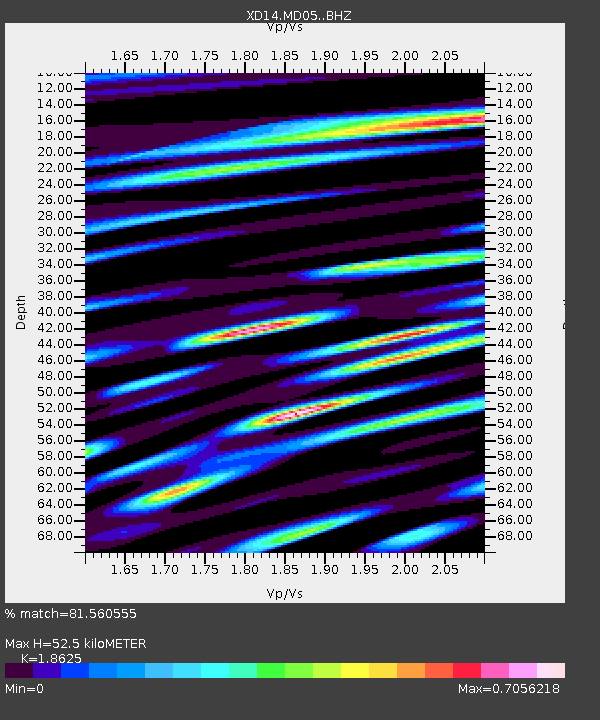
| Estimated Moho Depth: |
52.5 km |
| Estimated Crust Vp/Vs: |
1.86 |
| Assumed Crust Vp: |
6.566 km/s |
| Estimated Crust Vs: |
3.525 km/s |
| Estimated Crust Poisson's Ratio: |
0.30 |
|
| Radial Match: |
81.560555 % |
| Radial Bump: |
400 |
| Transverse Match: |
85.55765 % |
| Transverse Bump: |
400 |
| SOD ConfigId: |
7422571 |
| Insert Time: |
2019-04-19 03:18:36.926 +0000 |
| GWidth: |
2.5 |
| Max Bumps: |
400 |
| Tol: |
0.001 |
|

Signal To Noise
| Channel | StoN | STA | LTA |
| XD:MD05: :BHZ:20150530T11:33:06.13498Z | 117.51713 | 1.0575604E-4 | 8.9992017E-7 |
| XD:MD05: :BHN:20150530T11:33:06.13498Z | 82.71844 | 2.2250691E-5 | 2.6899315E-7 |
| XD:MD05: :BHE:20150530T11:33:06.13498Z | 74.734314 | 3.0053594E-5 | 4.0213916E-7 |
| Arrivals |
| Ps | 7.1 SECOND |
| PpPs | 22 SECOND |
| PsPs/PpSs | 29 SECOND |


