You are here: Home > Network List > XD14 - Illuminating the architecture of the greater Mount St. Helens magmatic systems f Stations List
> Station ME02 "Mount St Helens, WA" > Earthquake Result Viewer
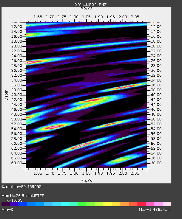
ME02 "Mount St Helens, WA" - Earthquake Result Viewer
| Earthquake location: |
Bonin Islands, Japan Region |
| Earthquake latitude/longitude: |
27.8/140.5 |
| Earthquake time(UTC): |
2015/05/30 (150) 11:23:02 GMT |
| Earthquake Depth: |
678 km |
| Earthquake Magnitude: |
7.8 MWP, 8.5 MI |
| Earthquake Catalog/Contributor: |
NEIC PDE/NEIC COMCAT |
|
| Network: |
XD Illuminating the architecture of the greater Mount St. Helens magmatic systems f |
| Station: |
ME02 "Mount St Helens, WA" |
| Lat/Lon: |
46.44 N/122.71 W |
| Elevation: |
158 m |
|
| Distance: |
74.8 deg |
| Az: |
45.376 deg |
| Baz: |
294.292 deg |
| Ray Param: |
0.049805924 |
| Estimated Moho Depth: |
26.5 km |
| Estimated Crust Vp/Vs: |
1.61 |
| Assumed Crust Vp: |
6.566 km/s |
| Estimated Crust Vs: |
4.091 km/s |
| Estimated Crust Poisson's Ratio: |
0.18 |
|
| Radial Match: |
80.469955 % |
| Radial Bump: |
400 |
| Transverse Match: |
76.38832 % |
| Transverse Bump: |
400 |
| SOD ConfigId: |
7422571 |
| Insert Time: |
2019-04-19 03:18:38.632 +0000 |
| GWidth: |
2.5 |
| Max Bumps: |
400 |
| Tol: |
0.001 |
|

Signal To Noise
| Channel | StoN | STA | LTA |
| XD:ME02: :BHZ:20150530T11:33:04.824983Z | 203.73425 | 1.9196927E-4 | 9.4225334E-7 |
| XD:ME02: :BHN:20150530T11:33:04.824983Z | 63.778942 | 3.0070454E-5 | 4.7147935E-7 |
| XD:ME02: :BHE:20150530T11:33:04.824983Z | 119.24511 | 6.316624E-5 | 5.297176E-7 |
| Arrivals |
| Ps | 2.5 SECOND |
| PpPs | 10 SECOND |
| PsPs/PpSs | 13 SECOND |


