You are here: Home > Network List > XD14 - Illuminating the architecture of the greater Mount St. Helens magmatic systems f Stations List
> Station MN07 "Mount St Helens, WA" > Earthquake Result Viewer
MN07 "Mount St Helens, WA" - Earthquake Result Viewer
| Earthquake location: |
Bonin Islands, Japan Region |
| Earthquake latitude/longitude: |
27.8/140.5 |
| Earthquake time(UTC): |
2015/05/30 (150) 11:23:02 GMT |
| Earthquake Depth: |
678 km |
| Earthquake Magnitude: |
7.8 MWP, 8.5 MI |
| Earthquake Catalog/Contributor: |
NEIC PDE/NEIC COMCAT |
|
| Network: |
XD Illuminating the architecture of the greater Mount St. Helens magmatic systems f |
| Station: |
MN07 "Mount St Helens, WA" |
| Lat/Lon: |
45.99 N/122.08 W |
| Elevation: |
861 m |
|
| Distance: |
75.3 deg |
| Az: |
45.61 deg |
| Baz: |
294.802 deg |
| Ray Param: |
0.049434178 |
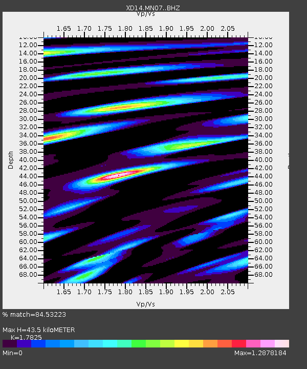
| Estimated Moho Depth: |
43.5 km |
| Estimated Crust Vp/Vs: |
1.78 |
| Assumed Crust Vp: |
6.566 km/s |
| Estimated Crust Vs: |
3.684 km/s |
| Estimated Crust Poisson's Ratio: |
0.27 |
|
| Radial Match: |
84.53223 % |
| Radial Bump: |
400 |
| Transverse Match: |
81.63529 % |
| Transverse Bump: |
400 |
| SOD ConfigId: |
7422571 |
| Insert Time: |
2019-04-19 03:19:18.343 +0000 |
| GWidth: |
2.5 |
| Max Bumps: |
400 |
| Tol: |
0.001 |
|

Signal To Noise
| Channel | StoN | STA | LTA |
| XD:MN07: :BHZ:20150530T11:33:08.030Z | 120.59632 | 1.12732E-4 | 9.3478803E-7 |
| XD:MN07: :BHN:20150530T11:33:08.030Z | 108.68336 | 2.5086676E-5 | 2.3082355E-7 |
| XD:MN07: :BHE:20150530T11:33:08.030Z | 105.32066 | 4.0473147E-5 | 3.8428496E-7 |
| Arrivals |
| Ps | 5.3 SECOND |
| PpPs | 18 SECOND |
| PsPs/PpSs | 23 SECOND |


