You are here: Home > Network List > XL12 - Hangay Dome, Mongolia Stations List
> Station AT01 AT01 > Earthquake Result Viewer
AT01 AT01 - Earthquake Result Viewer
| Earthquake location: |
Bonin Islands, Japan Region |
| Earthquake latitude/longitude: |
27.8/140.5 |
| Earthquake time(UTC): |
2015/05/30 (150) 11:23:02 GMT |
| Earthquake Depth: |
678 km |
| Earthquake Magnitude: |
7.8 MWP, 8.5 MI |
| Earthquake Catalog/Contributor: |
NEIC PDE/NEIC COMCAT |
|
| Network: |
XL Hangay Dome, Mongolia |
| Station: |
AT01 AT01 |
| Lat/Lon: |
45.36 N/93.62 E |
| Elevation: |
1561 m |
|
| Distance: |
40.9 deg |
| Az: |
308.157 deg |
| Baz: |
98.962 deg |
| Ray Param: |
0.07039757 |
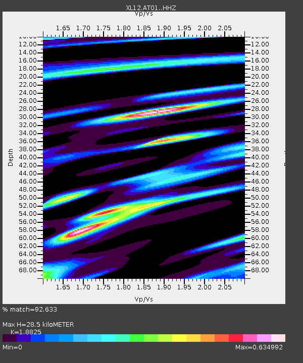
| Estimated Moho Depth: |
28.5 km |
| Estimated Crust Vp/Vs: |
1.88 |
| Assumed Crust Vp: |
6.353 km/s |
| Estimated Crust Vs: |
3.375 km/s |
| Estimated Crust Poisson's Ratio: |
0.30 |
|
| Radial Match: |
92.633 % |
| Radial Bump: |
280 |
| Transverse Match: |
73.46996 % |
| Transverse Bump: |
400 |
| SOD ConfigId: |
7422571 |
| Insert Time: |
2019-04-19 03:19:28.403 +0000 |
| GWidth: |
2.5 |
| Max Bumps: |
400 |
| Tol: |
0.001 |
|

Signal To Noise
| Channel | StoN | STA | LTA |
| XL:AT01: :HHZ:20150530T11:29:18.760011Z | 118.300964 | 7.42189E-5 | 6.273736E-7 |
| XL:AT01: :HHN:20150530T11:29:18.760011Z | 95.14709 | 8.940136E-6 | 9.396121E-8 |
| XL:AT01: :HHE:20150530T11:29:18.760011Z | 81.91387 | 4.2084128E-5 | 5.137607E-7 |
| Arrivals |
| Ps | 4.2 SECOND |
| PpPs | 12 SECOND |
| PsPs/PpSs | 16 SECOND |


