You are here: Home > Network List > XL12 - Hangay Dome, Mongolia Stations List
> Station AT10 AT10 > Earthquake Result Viewer
AT10 AT10 - Earthquake Result Viewer
| Earthquake location: |
Bonin Islands, Japan Region |
| Earthquake latitude/longitude: |
27.8/140.5 |
| Earthquake time(UTC): |
2015/05/30 (150) 11:23:02 GMT |
| Earthquake Depth: |
678 km |
| Earthquake Magnitude: |
7.8 MWP, 8.5 MI |
| Earthquake Catalog/Contributor: |
NEIC PDE/NEIC COMCAT |
|
| Network: |
XL Hangay Dome, Mongolia |
| Station: |
AT10 AT10 |
| Lat/Lon: |
44.62 N/94.91 E |
| Elevation: |
1390 m |
|
| Distance: |
39.9 deg |
| Az: |
307.244 deg |
| Baz: |
99.176 deg |
| Ray Param: |
0.07097383 |
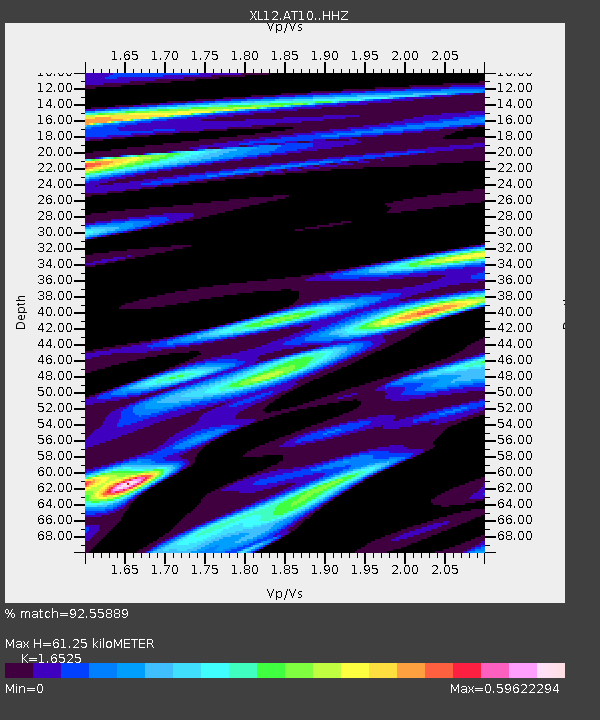
| Estimated Moho Depth: |
61.25 km |
| Estimated Crust Vp/Vs: |
1.65 |
| Assumed Crust Vp: |
6.353 km/s |
| Estimated Crust Vs: |
3.844 km/s |
| Estimated Crust Poisson's Ratio: |
0.21 |
|
| Radial Match: |
92.55889 % |
| Radial Bump: |
350 |
| Transverse Match: |
74.27033 % |
| Transverse Bump: |
400 |
| SOD ConfigId: |
7422571 |
| Insert Time: |
2019-04-19 03:19:33.539 +0000 |
| GWidth: |
2.5 |
| Max Bumps: |
400 |
| Tol: |
0.001 |
|

Signal To Noise
| Channel | StoN | STA | LTA |
| XL:AT10: :HHZ:20150530T11:29:10.750001Z | 112.02964 | 8.7948465E-5 | 7.850464E-7 |
| XL:AT10: :HHN:20150530T11:29:10.750001Z | 192.0958 | 1.740636E-5 | 9.061292E-8 |
| XL:AT10: :HHE:20150530T11:29:10.750001Z | 85.266884 | 4.7837886E-5 | 5.610371E-7 |
| Arrivals |
| Ps | 6.7 SECOND |
| PpPs | 24 SECOND |
| PsPs/PpSs | 31 SECOND |


