You are here: Home > Network List > PE - Penn State Network Stations List
> Station PAGS PA Geological Survey > Earthquake Result Viewer
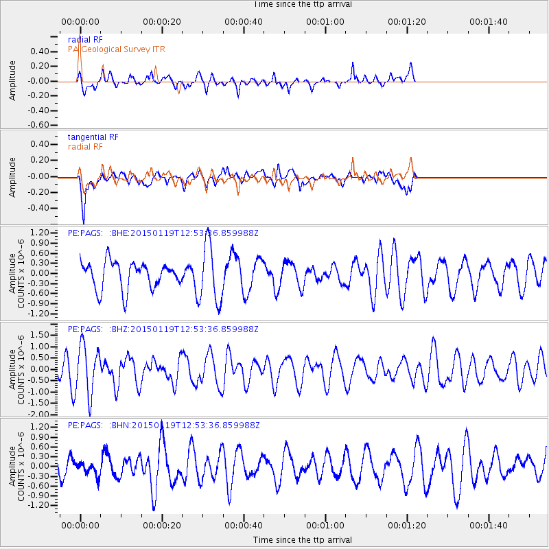
PAGS PA Geological Survey - Earthquake Result Viewer
*The percent match for this event was below the threshold and hence no stack was calculated.
| Earthquake location: |
Greenland Sea |
| Earthquake latitude/longitude: |
73.2/6.4 |
| Earthquake time(UTC): |
2015/01/19 (019) 12:45:13 GMT |
| Earthquake Depth: |
10 km |
| Earthquake Magnitude: |
5.5 MB |
| Earthquake Catalog/Contributor: |
NEIC PDE/NEIC COMCAT |
|
| Network: |
PE Penn State Network |
| Station: |
PAGS PA Geological Survey |
| Lat/Lon: |
40.23 N/76.72 W |
| Elevation: |
120 m |
|
| Distance: |
50.1 deg |
| Az: |
277.461 deg |
| Baz: |
22.086 deg |
| Ray Param: |
$rayparam |
*The percent match for this event was below the threshold and hence was not used in the summary stack. |
|
| Radial Match: |
75.54884 % |
| Radial Bump: |
361 |
| Transverse Match: |
61.848457 % |
| Transverse Bump: |
400 |
| SOD ConfigId: |
837871 |
| Insert Time: |
2015-02-02 13:12:07.811 +0000 |
| GWidth: |
2.5 |
| Max Bumps: |
400 |
| Tol: |
0.001 |
|
Signal To Noise
| Channel | StoN | STA | LTA |
| PE:PAGS: :BHZ:20150119T12:53:36.859988Z | 2.0923965 | 1.0833529E-6 | 5.17757E-7 |
| PE:PAGS: :BHN:20150119T12:53:36.859988Z | 0.62776417 | 2.1371113E-7 | 3.404322E-7 |
| PE:PAGS: :BHE:20150119T12:53:36.859988Z | 2.2256494 | 8.8906705E-7 | 3.9946408E-7 |
| Arrivals |
| Ps | |
| PpPs | |
| PsPs/PpSs | |


