You are here: Home > Network List > IU - Global Seismograph Network (GSN - IRIS/USGS) Stations List
> Station CTAO Charters Towers, Australia > Earthquake Result Viewer
CTAO Charters Towers, Australia - Earthquake Result Viewer
| Earthquake location: |
Mindanao, Philippines |
| Earthquake latitude/longitude: |
6.7/123.4 |
| Earthquake time(UTC): |
2009/10/04 (277) 10:58:00 GMT |
| Earthquake Depth: |
620 km |
| Earthquake Magnitude: |
6.4 MB, 6.6 MW, 6.6 MW |
| Earthquake Catalog/Contributor: |
WHDF/NEIC |
|
| Network: |
IU Global Seismograph Network (GSN - IRIS/USGS) |
| Station: |
CTAO Charters Towers, Australia |
| Lat/Lon: |
20.09 S/146.25 E |
| Elevation: |
357 m |
|
| Distance: |
34.9 deg |
| Az: |
140.298 deg |
| Baz: |
317.545 deg |
| Ray Param: |
0.07429067 |
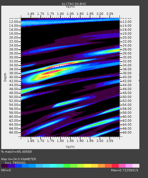
| Estimated Moho Depth: |
34.0 km |
| Estimated Crust Vp/Vs: |
1.80 |
| Assumed Crust Vp: |
6.522 km/s |
| Estimated Crust Vs: |
3.633 km/s |
| Estimated Crust Poisson's Ratio: |
0.27 |
|
| Radial Match: |
95.48559 % |
| Radial Bump: |
288 |
| Transverse Match: |
80.96346 % |
| Transverse Bump: |
400 |
| SOD ConfigId: |
1 |
| Insert Time: |
2010-02-19 00:30:50.527 +0000 |
| GWidth: |
2.5 |
| Max Bumps: |
400 |
| Tol: |
0.001 |
|

Signal To Noise
| Channel | StoN | STA | LTA |
| IU:CTAO:00:BHZ:20091004T11:03:31.547991Z | 143.1982 | 2.2447812E-5 | 1.5676045E-7 |
| IU:CTAO:00:BHN:20091004T11:03:31.547991Z | 139.2806 | 1.024552E-5 | 7.356029E-8 |
| IU:CTAO:00:BHE:20091004T11:03:31.547991Z | 71.18694 | 9.354218E-6 | 1.3140357E-7 |
| Arrivals |
| Ps | 4.5 SECOND |
| PpPs | 14 SECOND |
| PsPs/PpSs | 18 SECOND |


