You are here: Home > Network List > CI - Caltech Regional Seismic Network Stations List
> Station OSI Osito Audit > Earthquake Result Viewer
OSI Osito Audit - Earthquake Result Viewer
| Earthquake location: |
South Of Fiji Islands |
| Earthquake latitude/longitude: |
-22.1/-176.8 |
| Earthquake time(UTC): |
1997/10/14 (287) 09:53:18 GMT |
| Earthquake Depth: |
167 km |
| Earthquake Magnitude: |
6.7 MB, 7.7 UNKNOWN, 7.4 ME |
| Earthquake Catalog/Contributor: |
WHDF/NEIC |
|
| Network: |
CI Caltech Regional Seismic Network |
| Station: |
OSI Osito Audit |
| Lat/Lon: |
34.61 N/118.72 W |
| Elevation: |
718 m |
|
| Distance: |
78.9 deg |
| Az: |
45.501 deg |
| Baz: |
233.323 deg |
| Ray Param: |
0.048946813 |
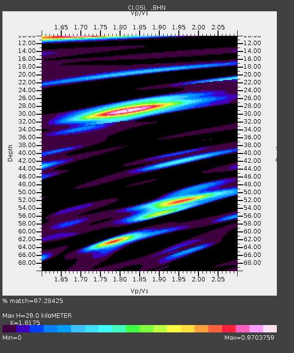
| Estimated Moho Depth: |
29.0 km |
| Estimated Crust Vp/Vs: |
1.82 |
| Assumed Crust Vp: |
6.1 km/s |
| Estimated Crust Vs: |
3.356 km/s |
| Estimated Crust Poisson's Ratio: |
0.28 |
|
| Radial Match: |
97.28425 % |
| Radial Bump: |
400 |
| Transverse Match: |
93.88745 % |
| Transverse Bump: |
400 |
| SOD ConfigId: |
3787 |
| Insert Time: |
2010-02-25 21:27:53.570 +0000 |
| GWidth: |
2.5 |
| Max Bumps: |
400 |
| Tol: |
0.001 |
|

Signal To Noise
| Channel | StoN | STA | LTA |
| CI:OSI: :BHN:19971014T10:04:31.618005Z | 1.8742707 | 5.146166E-7 | 2.74569E-7 |
| CI:OSI: :BHE:19971014T10:04:31.618005Z | 1.6175969 | 4.354598E-7 | 2.6920168E-7 |
| CI:OSI: :BHZ:19971014T10:04:31.618005Z | 3.171713 | 1.4760326E-6 | 4.6537392E-7 |
| Arrivals |
| Ps | 4.0 SECOND |
| PpPs | 13 SECOND |
| PsPs/PpSs | 17 SECOND |


