You are here: Home > Network List > TA - USArray Transportable Network (new EarthScope stations) Stations List
> Station 833A Chaparral WMA, Artesia Wells, TX, USA > Earthquake Result Viewer
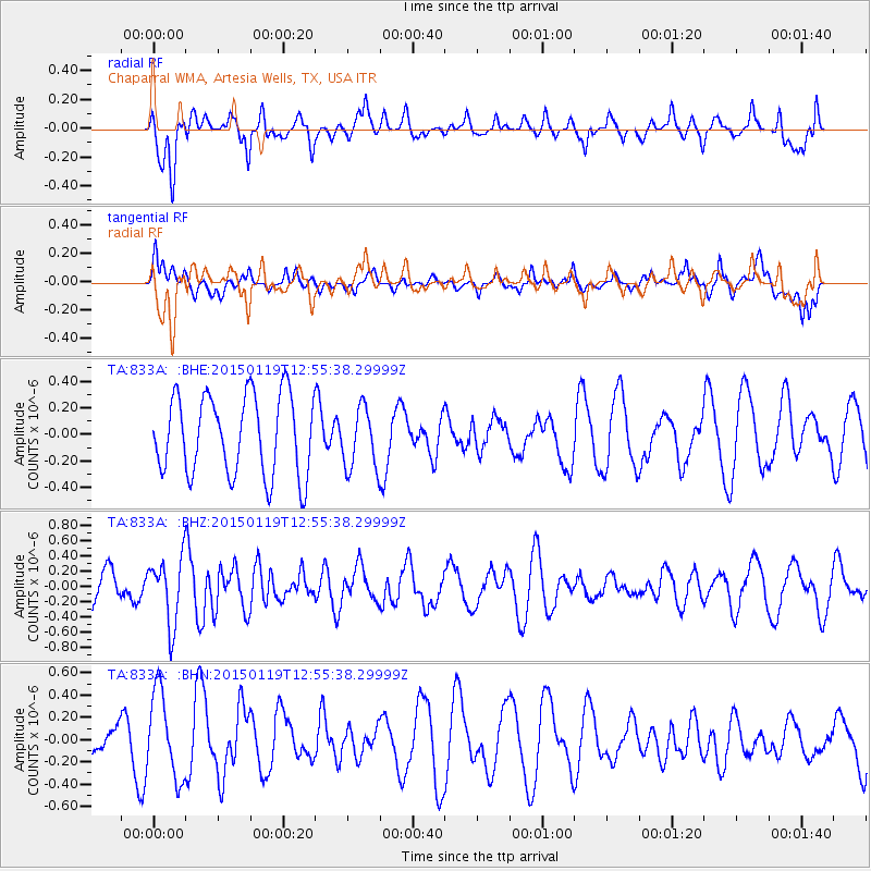
833A Chaparral WMA, Artesia Wells, TX, USA - Earthquake Result Viewer
*The percent match for this event was below the threshold and hence no stack was calculated.
| Earthquake location: |
Greenland Sea |
| Earthquake latitude/longitude: |
73.2/6.4 |
| Earthquake time(UTC): |
2015/01/19 (019) 12:45:13 GMT |
| Earthquake Depth: |
10 km |
| Earthquake Magnitude: |
5.5 MB |
| Earthquake Catalog/Contributor: |
NEIC PDE/NEIC COMCAT |
|
| Network: |
TA USArray Transportable Network (new EarthScope stations) |
| Station: |
833A Chaparral WMA, Artesia Wells, TX, USA |
| Lat/Lon: |
28.32 N/99.39 W |
| Elevation: |
171 m |
|
| Distance: |
67.6 deg |
| Az: |
293.412 deg |
| Baz: |
17.59 deg |
| Ray Param: |
$rayparam |
*The percent match for this event was below the threshold and hence was not used in the summary stack. |
|
| Radial Match: |
52.416576 % |
| Radial Bump: |
400 |
| Transverse Match: |
52.615635 % |
| Transverse Bump: |
400 |
| SOD ConfigId: |
837871 |
| Insert Time: |
2015-02-02 13:14:35.494 +0000 |
| GWidth: |
2.5 |
| Max Bumps: |
400 |
| Tol: |
0.001 |
|
Signal To Noise
| Channel | StoN | STA | LTA |
| TA:833A: :BHZ:20150119T12:55:38.29999Z | 2.01548 | 4.2911833E-7 | 2.1291123E-7 |
| TA:833A: :BHN:20150119T12:55:38.29999Z | 2.0020537 | 3.8947928E-7 | 1.9453987E-7 |
| TA:833A: :BHE:20150119T12:55:38.29999Z | 0.7661314 | 2.2912802E-7 | 2.9907144E-7 |
| Arrivals |
| Ps | |
| PpPs | |
| PsPs/PpSs | |


