You are here: Home > Network List > TA - USArray Transportable Network (new EarthScope stations) Stations List
> Station H63A New Sharon, ME, USA > Earthquake Result Viewer
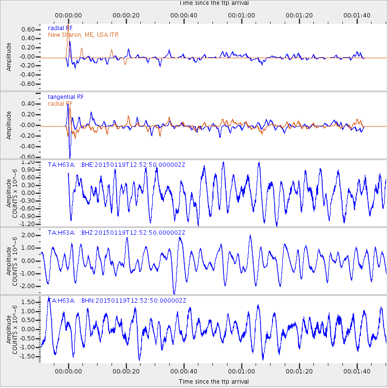
H63A New Sharon, ME, USA - Earthquake Result Viewer
*The percent match for this event was below the threshold and hence no stack was calculated.
| Earthquake location: |
Greenland Sea |
| Earthquake latitude/longitude: |
73.2/6.4 |
| Earthquake time(UTC): |
2015/01/19 (019) 12:45:13 GMT |
| Earthquake Depth: |
10 km |
| Earthquake Magnitude: |
5.5 MB |
| Earthquake Catalog/Contributor: |
NEIC PDE/NEIC COMCAT |
|
| Network: |
TA USArray Transportable Network (new EarthScope stations) |
| Station: |
H63A New Sharon, ME, USA |
| Lat/Lon: |
44.66 N/70.04 W |
| Elevation: |
109 m |
|
| Distance: |
44.0 deg |
| Az: |
273.603 deg |
| Baz: |
23.956 deg |
| Ray Param: |
$rayparam |
*The percent match for this event was below the threshold and hence was not used in the summary stack. |
|
| Radial Match: |
53.773464 % |
| Radial Bump: |
400 |
| Transverse Match: |
54.377518 % |
| Transverse Bump: |
400 |
| SOD ConfigId: |
837871 |
| Insert Time: |
2015-02-02 13:16:02.509 +0000 |
| GWidth: |
2.5 |
| Max Bumps: |
400 |
| Tol: |
0.001 |
|
Signal To Noise
| Channel | StoN | STA | LTA |
| TA:H63A: :BHZ:20150119T12:52:50.000002Z | 1.1902872 | 9.2696297E-7 | 7.787725E-7 |
| TA:H63A: :BHN:20150119T12:52:50.000002Z | 1.0207396 | 6.729618E-7 | 6.5928845E-7 |
| TA:H63A: :BHE:20150119T12:52:50.000002Z | 1.0365942 | 4.1120228E-7 | 3.9668586E-7 |
| Arrivals |
| Ps | |
| PpPs | |
| PsPs/PpSs | |


