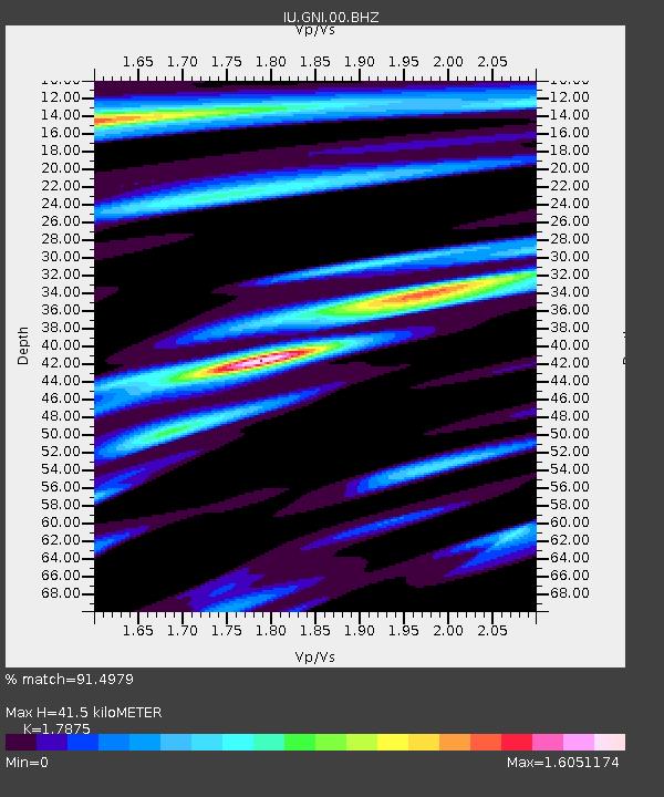
GNI Garni, Armenia - Earthquake Result Viewer
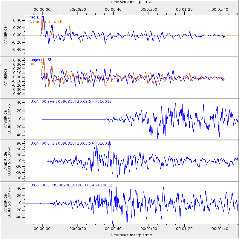
Earthquake location: Andaman Islands, India Region
Earthquake latitude/longitude: 14.1/92.9
Earthquake time(UTC): 2009/08/10 (222) 19:55:35 GMT
Earthquake Depth: 4.7 km
Earthquake Magnitude: 6.9 MB, 7.6 MS, 7.5 MW, 7.5 MW
Earthquake Catalog/Contributor: WHDF/NEIC
Network: IU Global Seismograph Network (GSN - IRIS/USGS)
Station: GNI Garni, Armenia
Lat/Lon: 40.15 N/44.74 E
Elevation: 1609 m
Distance: 49.3 deg
Az: 311.172 deg
Baz: 107.67 deg
Ray Param: 0.06878139
Estimated Moho Depth: 41.5 km
Estimated Crust Vp/Vs: 1.79
Assumed Crust Vp: 6.291 km/s
Estimated Crust Vs: 3.519 km/s
Estimated Crust Poisson's Ratio: 0.27
Radial Match: 91.4979 %
Radial Bump: 400
Transverse Match: 93.87945 %
Transverse Bump: 400
SOD ConfigId: 2622
Insert Time: 2010-03-03 13:46:18.411 +0000
GWidth: 2.5
Max Bumps: 400
Tol: 0.001

Signal To Noise

ChannelStoNSTALTA
IU:GNI:00:BHZ:20090810T20:03:54.761001Z14.8640758.6885075E-75.8453068E-8
IU:GNI:00:BHN:20090810T20:03:54.761001Z1.44781041.0205246E-77.0487445E-8
IU:GNI:00:BHE:20090810T20:03:54.761001Z2.39016961.6535903E-76.9182974E-8
Arrivals
Ps5.5 SECOND
PpPs17 SECOND
PsPs/PpSs23 SECOND