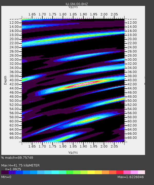
GNI Garni, Armenia - Earthquake Result Viewer
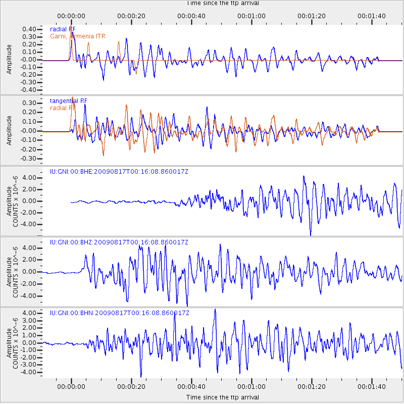
Earthquake location: Southwestern Ryukyu Isl., Japan
Earthquake latitude/longitude: 23.5/123.5
Earthquake time(UTC): 2009/08/17 (229) 00:05:49 GMT
Earthquake Depth: 20 km
Earthquake Magnitude: 6.2 MB, 6.6 MS, 6.7 MW, 6.6 MW
Earthquake Catalog/Contributor: WHDF/NEIC
Network: IU Global Seismograph Network (GSN - IRIS/USGS)
Station: GNI Garni, Armenia
Lat/Lon: 40.15 N/44.74 E
Elevation: 1609 m
Distance: 66.9 deg
Az: 305.2 deg
Baz: 78.146 deg
Ray Param: 0.0572673
Estimated Moho Depth: 41.75 km
Estimated Crust Vp/Vs: 1.89
Assumed Crust Vp: 6.291 km/s
Estimated Crust Vs: 3.324 km/s
Estimated Crust Poisson's Ratio: 0.31
Radial Match: 89.75749 %
Radial Bump: 400
Transverse Match: 74.439095 %
Transverse Bump: 400
SOD ConfigId: 2622
Insert Time: 2010-03-03 13:46:27.569 +0000
GWidth: 2.5
Max Bumps: 400
Tol: 0.001

Signal To Noise

ChannelStoNSTALTA
IU:GNI:00:BHZ:20090817T00:16:08.860017Z12.9086458.128482E-76.29693E-8
IU:GNI:00:BHN:20090817T00:16:08.860017Z0.77831297.20197E-89.25331E-8
IU:GNI:00:BHE:20090817T00:16:08.860017Z1.26566031.5007882E-71.1857748E-7
Arrivals
Ps6.1 SECOND
PpPs19 SECOND
PsPs/PpSs25 SECOND