You are here: Home > Network List > TA - USArray Transportable Network (new EarthScope stations) Stations List
> Station L04D Klamath Falls, OR, USA > Earthquake Result Viewer
L04D Klamath Falls, OR, USA - Earthquake Result Viewer
*The percent match for this event was below the threshold and hence no stack was calculated.
| Earthquake location: |
Greenland Sea |
| Earthquake latitude/longitude: |
73.2/6.4 |
| Earthquake time(UTC): |
2015/01/19 (019) 12:45:13 GMT |
| Earthquake Depth: |
10 km |
| Earthquake Magnitude: |
5.5 MB |
| Earthquake Catalog/Contributor: |
NEIC PDE/NEIC COMCAT |
|
| Network: |
TA USArray Transportable Network (new EarthScope stations) |
| Station: |
L04D Klamath Falls, OR, USA |
| Lat/Lon: |
42.22 N/122.30 W |
| Elevation: |
1437 m |
|
| Distance: |
59.6 deg |
| Az: |
317.814 deg |
| Baz: |
15.216 deg |
| Ray Param: |
$rayparam |
*The percent match for this event was below the threshold and hence was not used in the summary stack. |
|
| Radial Match: |
48.088562 % |
| Radial Bump: |
380 |
| Transverse Match: |
55.136303 % |
| Transverse Bump: |
400 |
| SOD ConfigId: |
837871 |
| Insert Time: |
2015-02-02 13:16:42.578 +0000 |
| GWidth: |
2.5 |
| Max Bumps: |
400 |
| Tol: |
0.001 |
|
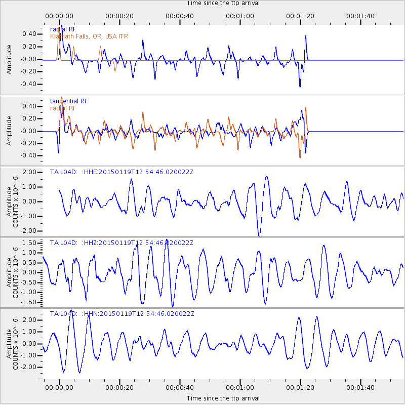
Signal To Noise
| Channel | StoN | STA | LTA |
| TA:L04D: :HHZ:20150119T12:54:46.020022Z | 0.85951287 | 5.004275E-7 | 5.8222224E-7 |
| TA:L04D: :HHN:20150119T12:54:46.020022Z | 2.1271331 | 1.7265586E-6 | 8.1168344E-7 |
| TA:L04D: :HHE:20150119T12:54:46.020022Z | 1.2072114 | 6.324893E-7 | 5.239259E-7 |
| Arrivals |
| Ps | |
| PpPs | |
| PsPs/PpSs | |


