You are here: Home > Network List > TA - USArray Transportable Network (new EarthScope stations) Stations List
> Station O58A Lewisberry, PA, USA > Earthquake Result Viewer
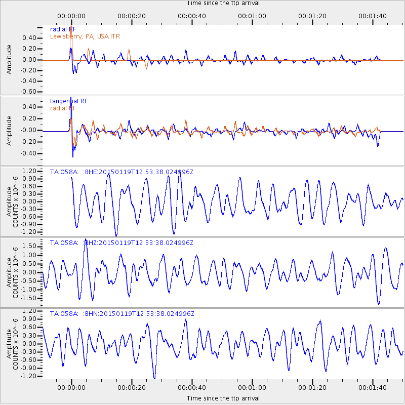
O58A Lewisberry, PA, USA - Earthquake Result Viewer
*The percent match for this event was below the threshold and hence no stack was calculated.
| Earthquake location: |
Greenland Sea |
| Earthquake latitude/longitude: |
73.2/6.4 |
| Earthquake time(UTC): |
2015/01/19 (019) 12:45:13 GMT |
| Earthquake Depth: |
10 km |
| Earthquake Magnitude: |
5.5 MB |
| Earthquake Catalog/Contributor: |
NEIC PDE/NEIC COMCAT |
|
| Network: |
TA USArray Transportable Network (new EarthScope stations) |
| Station: |
O58A Lewisberry, PA, USA |
| Lat/Lon: |
40.12 N/76.92 W |
| Elevation: |
321 m |
|
| Distance: |
50.2 deg |
| Az: |
277.595 deg |
| Baz: |
22.043 deg |
| Ray Param: |
$rayparam |
*The percent match for this event was below the threshold and hence was not used in the summary stack. |
|
| Radial Match: |
63.92241 % |
| Radial Bump: |
400 |
| Transverse Match: |
73.671486 % |
| Transverse Bump: |
400 |
| SOD ConfigId: |
837871 |
| Insert Time: |
2015-02-02 13:17:19.589 +0000 |
| GWidth: |
2.5 |
| Max Bumps: |
400 |
| Tol: |
0.001 |
|
Signal To Noise
| Channel | StoN | STA | LTA |
| TA:O58A: :BHZ:20150119T12:53:38.024996Z | 1.6980393 | 9.031983E-7 | 5.319066E-7 |
| TA:O58A: :BHN:20150119T12:53:38.024996Z | 1.142938 | 4.1671177E-7 | 3.6459699E-7 |
| TA:O58A: :BHE:20150119T12:53:38.024996Z | 1.1712787 | 7.0544564E-7 | 6.022868E-7 |
| Arrivals |
| Ps | |
| PpPs | |
| PsPs/PpSs | |


