You are here: Home > Network List > CI - Caltech Regional Seismic Network Stations List
> Station MPP McPhearson Peak > Earthquake Result Viewer
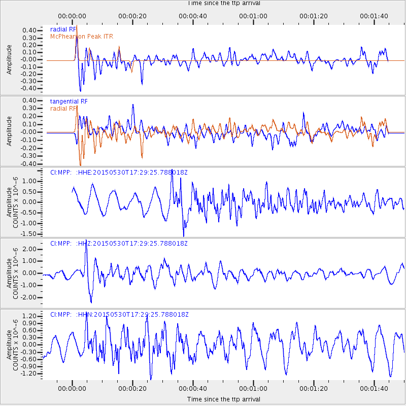
MPP McPhearson Peak - Earthquake Result Viewer
*The percent match for this event was below the threshold and hence no stack was calculated.
| Earthquake location: |
Tonga Islands |
| Earthquake latitude/longitude: |
-15.7/-173.3 |
| Earthquake time(UTC): |
2015/05/30 (150) 17:18:39 GMT |
| Earthquake Depth: |
51 km |
| Earthquake Magnitude: |
5.8 MB |
| Earthquake Catalog/Contributor: |
NEIC PDE/NEIC COMCAT |
|
| Network: |
CI Caltech Regional Seismic Network |
| Station: |
MPP McPhearson Peak |
| Lat/Lon: |
34.89 N/119.81 W |
| Elevation: |
1739 m |
|
| Distance: |
71.5 deg |
| Az: |
44.179 deg |
| Baz: |
234.724 deg |
| Ray Param: |
$rayparam |
*The percent match for this event was below the threshold and hence was not used in the summary stack. |
|
| Radial Match: |
54.154984 % |
| Radial Bump: |
400 |
| Transverse Match: |
67.66048 % |
| Transverse Bump: |
400 |
| SOD ConfigId: |
7422571 |
| Insert Time: |
2019-04-19 03:26:27.404 +0000 |
| GWidth: |
2.5 |
| Max Bumps: |
400 |
| Tol: |
0.001 |
|
Signal To Noise
| Channel | StoN | STA | LTA |
| CI:MPP: :HHZ:20150530T17:29:25.788018Z | 4.256421 | 8.326238E-7 | 1.9561594E-7 |
| CI:MPP: :HHN:20150530T17:29:25.788018Z | 1.9106417 | 5.582647E-7 | 2.9218702E-7 |
| CI:MPP: :HHE:20150530T17:29:25.788018Z | 1.6816503 | 6.5310354E-7 | 3.8837064E-7 |
| Arrivals |
| Ps | |
| PpPs | |
| PsPs/PpSs | |


