You are here: Home > Network List > TA - USArray Transportable Network (new EarthScope stations) Stations List
> Station T56A Rocky Mt, VA, USA > Earthquake Result Viewer
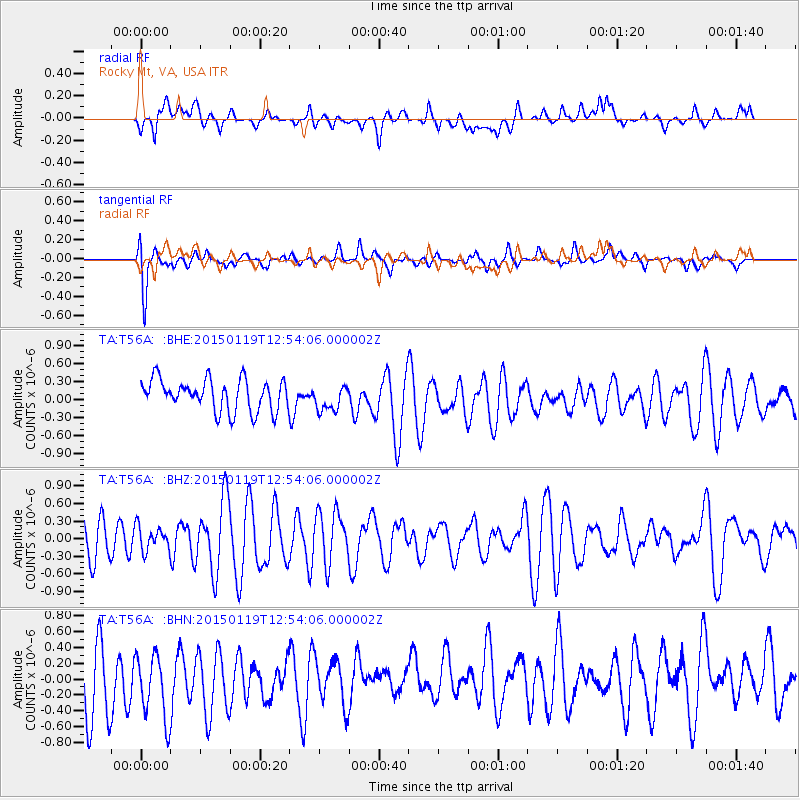
T56A Rocky Mt, VA, USA - Earthquake Result Viewer
*The percent match for this event was below the threshold and hence no stack was calculated.
| Earthquake location: |
Greenland Sea |
| Earthquake latitude/longitude: |
73.2/6.4 |
| Earthquake time(UTC): |
2015/01/19 (019) 12:45:13 GMT |
| Earthquake Depth: |
10 km |
| Earthquake Magnitude: |
5.5 MB |
| Earthquake Catalog/Contributor: |
NEIC PDE/NEIC COMCAT |
|
| Network: |
TA USArray Transportable Network (new EarthScope stations) |
| Station: |
T56A Rocky Mt, VA, USA |
| Lat/Lon: |
37.03 N/80.03 W |
| Elevation: |
387 m |
|
| Distance: |
54.0 deg |
| Az: |
279.032 deg |
| Baz: |
20.995 deg |
| Ray Param: |
$rayparam |
*The percent match for this event was below the threshold and hence was not used in the summary stack. |
|
| Radial Match: |
45.13765 % |
| Radial Bump: |
400 |
| Transverse Match: |
74.16528 % |
| Transverse Bump: |
400 |
| SOD ConfigId: |
837871 |
| Insert Time: |
2015-02-02 13:17:55.447 +0000 |
| GWidth: |
2.5 |
| Max Bumps: |
400 |
| Tol: |
0.001 |
|
Signal To Noise
| Channel | StoN | STA | LTA |
| TA:T56A: :BHZ:20150119T12:54:06.000002Z | 0.48864472 | 2.0551003E-7 | 4.2057147E-7 |
| TA:T56A: :BHN:20150119T12:54:06.000002Z | 1.0493654 | 4.475094E-7 | 4.2645715E-7 |
| TA:T56A: :BHE:20150119T12:54:06.000002Z | 0.8348372 | 2.1815538E-7 | 2.6131488E-7 |
| Arrivals |
| Ps | |
| PpPs | |
| PsPs/PpSs | |


