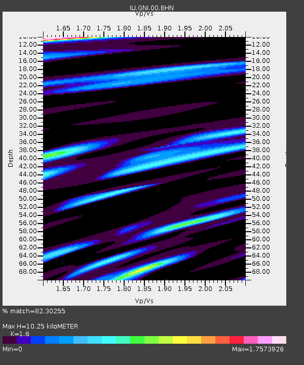
GNI Garni, Armenia - Earthquake Result Viewer
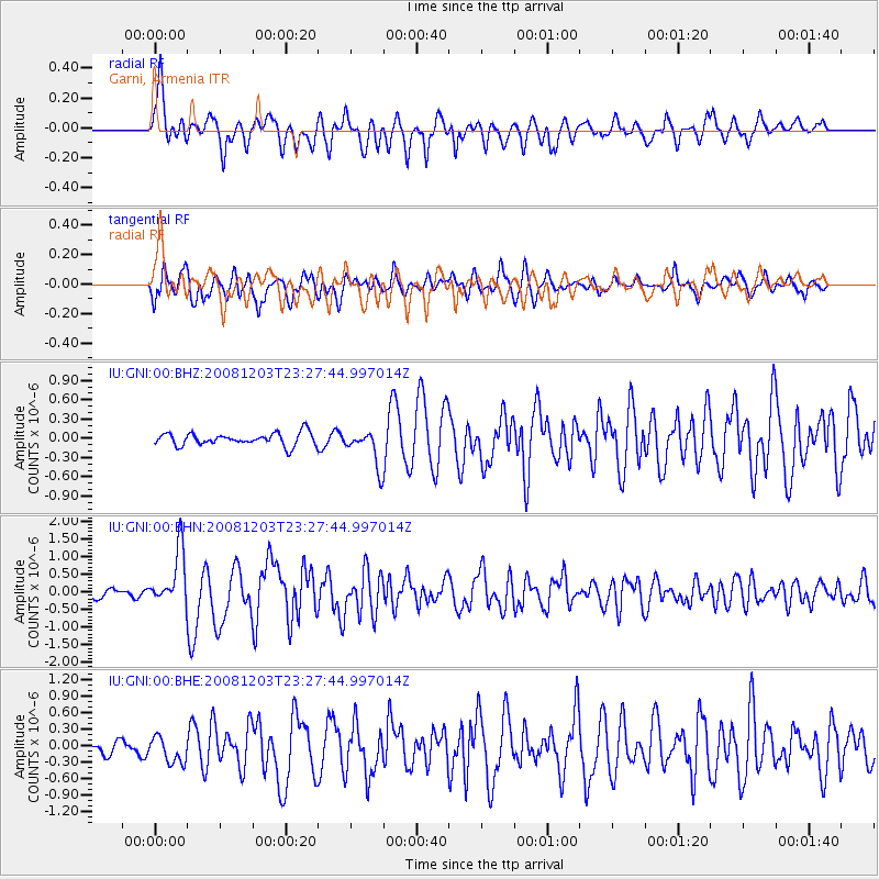
Earthquake location: Near East Coast Of Honshu, Japan
Earthquake latitude/longitude: 38.6/142.9
Earthquake time(UTC): 2008/12/03 (338) 23:16:54 GMT
Earthquake Depth: 14 km
Earthquake Magnitude: 5.6 MB, 5.5 MS, 5.8 MW, 5.8 MW
Earthquake Catalog/Contributor: WHDF/NEIC
Network: IU Global Seismograph Network (GSN - IRIS/USGS)
Station: GNI Garni, Armenia
Lat/Lon: 40.15 N/44.74 E
Elevation: 1609 m
Distance: 71.7 deg
Az: 306.947 deg
Baz: 54.794 deg
Ray Param: 0.05414191
Estimated Moho Depth: 10.25 km
Estimated Crust Vp/Vs: 1.60
Assumed Crust Vp: 6.291 km/s
Estimated Crust Vs: 3.932 km/s
Estimated Crust Poisson's Ratio: 0.18
Radial Match: 82.30255 %
Radial Bump: 400
Transverse Match: 70.93707 %
Transverse Bump: 400
SOD ConfigId: 2658
Insert Time: 2010-03-03 13:46:42.101 +0000
GWidth: 2.5
Max Bumps: 400
Tol: 0.001

Signal To Noise

ChannelStoNSTALTA
IU:GNI:00:BHN:20081203T23:27:44.997014Z7.90038827.8552335E-79.9428455E-8
IU:GNI:00:BHE:20081203T23:27:44.997014Z2.3828162.342758E-79.831888E-8
IU:GNI:00:BHZ:20081203T23:27:44.997014Z2.94608882.8540816E-79.687697E-8
Arrivals
Ps1.0 SECOND
PpPs4.1 SECOND
PsPs/PpSs5.1 SECOND