GNI Garni, Armenia - Earthquake Result Viewer
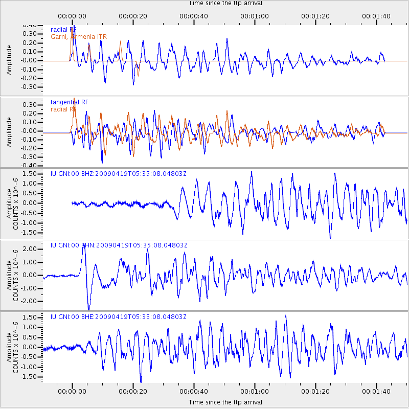
Earthquake location: Talaud Islands, Indonesia
Earthquake latitude/longitude: 4.1/126.7
Earthquake time(UTC): 2009/04/19 (109) 05:23:25 GMT
Earthquake Depth: 25 km
Earthquake Magnitude: 5.9 MB, 5.9 MS, 6.1 MW, 6.1 MW
Earthquake Catalog/Contributor: WHDF/NEIC
Network: IU Global Seismograph Network (GSN - IRIS/USGS)
Station: GNI Garni, Armenia
Lat/Lon: 40.15 N/44.74 E
Elevation: 1609 m
Distance: 81.2 deg
Az: 309.825 deg
Baz: 92.026 deg
Ray Param: 0.047735866
Estimated Moho Depth: 30.75 km
Estimated Crust Vp/Vs: 2.10
Assumed Crust Vp: 6.291 km/s
Estimated Crust Vs: 2.999 km/s
Estimated Crust Poisson's Ratio: 0.35
Radial Match: 84.533905 %
Radial Bump: 400
Transverse Match: 79.31294 %
Transverse Bump: 400
SOD ConfigId: 2658
Insert Time: 2010-03-03 13:46:44.358 +0000
GWidth: 2.5
Max Bumps: 400
Tol: 0.001

Signal To Noise

ChannelStoNSTALTA
IU:GNI:00:BHN:20090419T05:35:08.04803Z13.2430181.0201481E-67.703291E-8
IU:GNI:00:BHE:20090419T05:35:08.04803Z1.33694671.1135313E-78.328913E-8
IU:GNI:00:BHZ:20090419T05:35:08.04803Z4.0473933.0340124E-77.496214E-8
Arrivals
Ps5.5 SECOND
PpPs15 SECOND
PsPs/PpSs20 SECOND