You are here: Home > Network List > IU - Global Seismograph Network (GSN - IRIS/USGS) Stations List
> Station GNI Garni, Armenia > Earthquake Result Viewer
GNI Garni, Armenia - Earthquake Result Viewer
| Earthquake location: |
Mindanao, Philippines |
| Earthquake latitude/longitude: |
5.4/126.4 |
| Earthquake time(UTC): |
2009/06/14 (165) 05:58:43 GMT |
| Earthquake Depth: |
35 km |
| Earthquake Magnitude: |
5.7 MB, 5.7 MS, 6.1 MW, 6.1 MW |
| Earthquake Catalog/Contributor: |
WHDF/NEIC |
|
| Network: |
IU Global Seismograph Network (GSN - IRIS/USGS) |
| Station: |
GNI Garni, Armenia |
| Lat/Lon: |
40.15 N/44.74 E |
| Elevation: |
1609 m |
|
| Distance: |
80.2 deg |
| Az: |
309.677 deg |
| Baz: |
91.233 deg |
| Ray Param: |
0.048374686 |
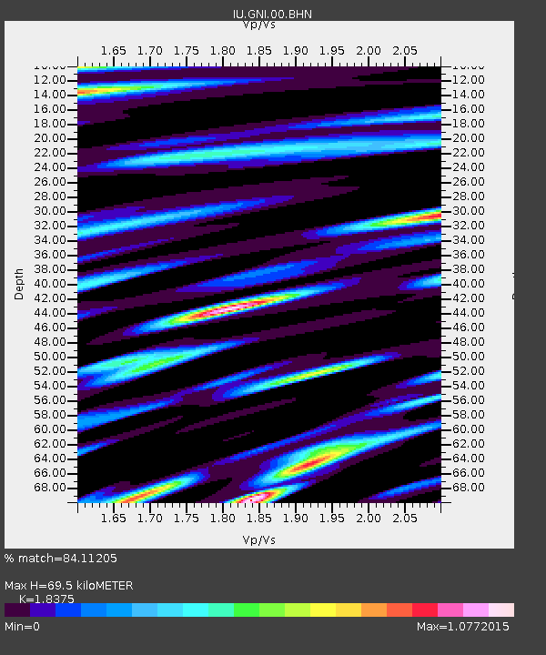
| Estimated Moho Depth: |
69.5 km |
| Estimated Crust Vp/Vs: |
1.84 |
| Assumed Crust Vp: |
6.291 km/s |
| Estimated Crust Vs: |
3.424 km/s |
| Estimated Crust Poisson's Ratio: |
0.29 |
|
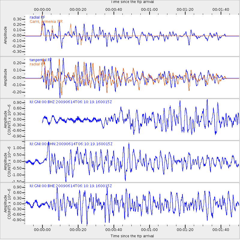
| Radial Match: |
84.11205 % |
| Radial Bump: |
400 |
| Transverse Match: |
81.30083 % |
| Transverse Bump: |
400 |
| SOD ConfigId: |
2648 |
| Insert Time: |
2010-03-03 13:46:45.929 +0000 |
| GWidth: |
2.5 |
| Max Bumps: |
400 |
| Tol: |
0.001 |
|
Signal To Noise
| Channel | StoN | STA | LTA |
| IU:GNI:00:BHN:20090614T06:10:19.160015Z | 10.222877 | 6.016628E-7 | 5.885455E-8 |
| IU:GNI:00:BHE:20090614T06:10:19.160015Z | 0.894283 | 8.337926E-8 | 9.323588E-8 |
| IU:GNI:00:BHZ:20090614T06:10:19.160015Z | 1.8358531 | 1.8401178E-7 | 1.00232306E-7 |
| Arrivals |
| Ps | 9.5 SECOND |
| PpPs | 31 SECOND |
| PsPs/PpSs | 40 SECOND |


