You are here: Home > Network List > TA - USArray Transportable Network (new EarthScope stations) Stations List
> Station U58A Oxford, NC, USA > Earthquake Result Viewer
U58A Oxford, NC, USA - Earthquake Result Viewer
*The percent match for this event was below the threshold and hence no stack was calculated.
| Earthquake location: |
Greenland Sea |
| Earthquake latitude/longitude: |
73.2/6.4 |
| Earthquake time(UTC): |
2015/01/19 (019) 12:45:13 GMT |
| Earthquake Depth: |
10 km |
| Earthquake Magnitude: |
5.5 MB |
| Earthquake Catalog/Contributor: |
NEIC PDE/NEIC COMCAT |
|
| Network: |
TA USArray Transportable Network (new EarthScope stations) |
| Station: |
U58A Oxford, NC, USA |
| Lat/Lon: |
36.39 N/78.55 W |
| Elevation: |
169 m |
|
| Distance: |
54.1 deg |
| Az: |
277.379 deg |
| Baz: |
20.907 deg |
| Ray Param: |
$rayparam |
*The percent match for this event was below the threshold and hence was not used in the summary stack. |
|
| Radial Match: |
49.180214 % |
| Radial Bump: |
400 |
| Transverse Match: |
58.244083 % |
| Transverse Bump: |
400 |
| SOD ConfigId: |
837871 |
| Insert Time: |
2015-02-02 13:18:07.000 +0000 |
| GWidth: |
2.5 |
| Max Bumps: |
400 |
| Tol: |
0.001 |
|
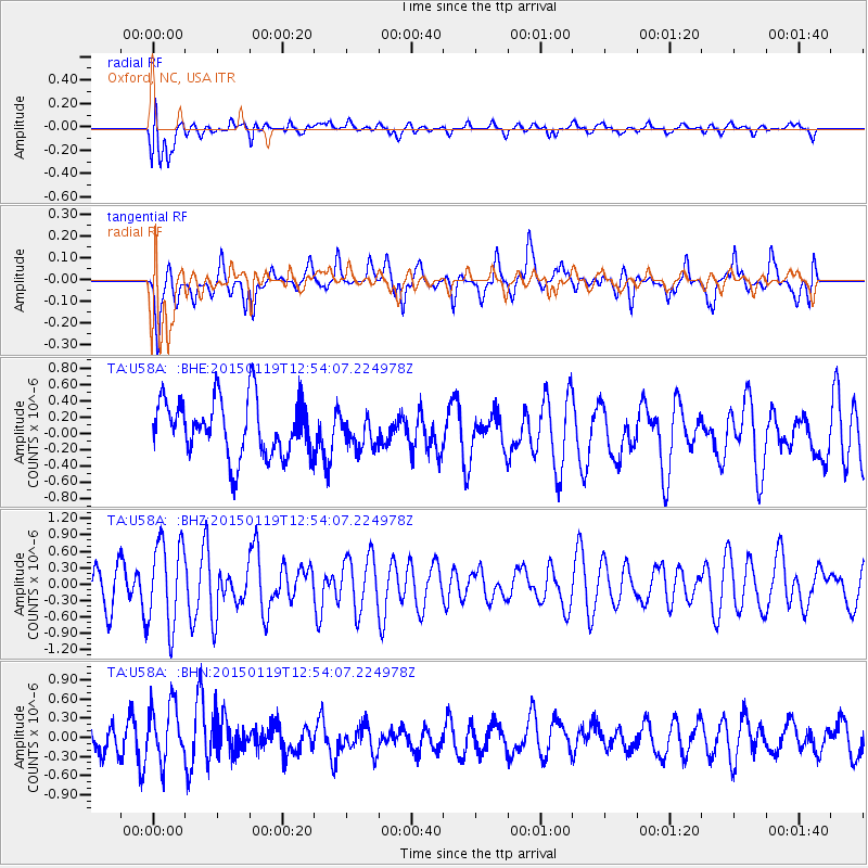
Signal To Noise
| Channel | StoN | STA | LTA |
| TA:U58A: :BHZ:20150119T12:54:07.224978Z | 2.181312 | 7.866066E-7 | 3.606117E-7 |
| TA:U58A: :BHN:20150119T12:54:07.224978Z | 1.803855 | 4.4368926E-7 | 2.4596727E-7 |
| TA:U58A: :BHE:20150119T12:54:07.224978Z | 0.5393436 | 1.872688E-7 | 3.4721614E-7 |
| Arrivals |
| Ps | |
| PpPs | |
| PsPs/PpSs | |


