You are here: Home > Network List > TA - USArray Transportable Network (new EarthScope stations) Stations List
> Station W56A Indian Trail, NC, USA > Earthquake Result Viewer
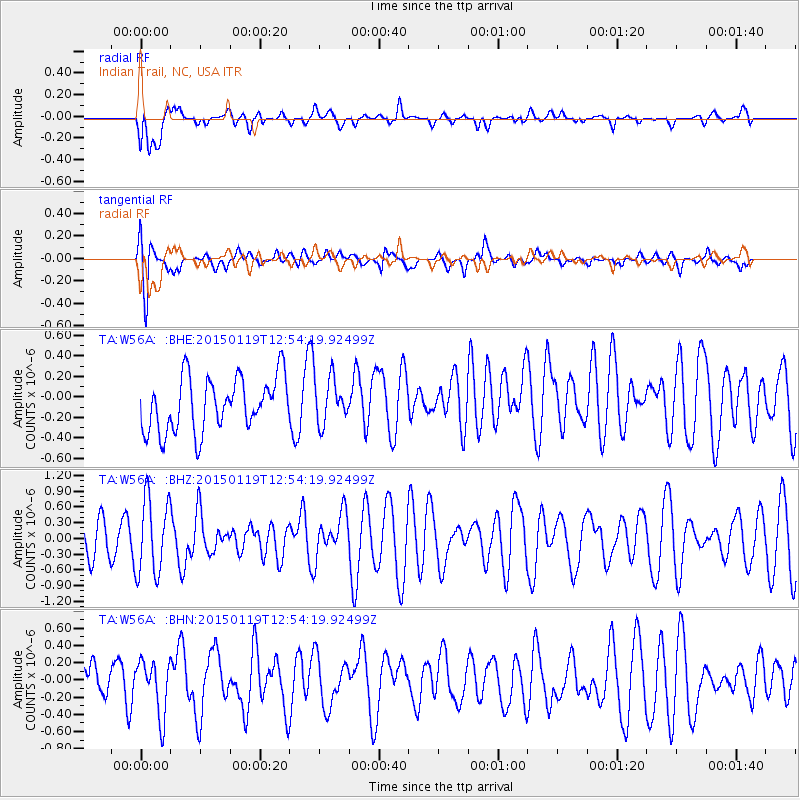
W56A Indian Trail, NC, USA - Earthquake Result Viewer
*The percent match for this event was below the threshold and hence no stack was calculated.
| Earthquake location: |
Greenland Sea |
| Earthquake latitude/longitude: |
73.2/6.4 |
| Earthquake time(UTC): |
2015/01/19 (019) 12:45:13 GMT |
| Earthquake Depth: |
10 km |
| Earthquake Magnitude: |
5.5 MB |
| Earthquake Catalog/Contributor: |
NEIC PDE/NEIC COMCAT |
|
| Network: |
TA USArray Transportable Network (new EarthScope stations) |
| Station: |
W56A Indian Trail, NC, USA |
| Lat/Lon: |
35.13 N/80.58 W |
| Elevation: |
177 m |
|
| Distance: |
55.9 deg |
| Az: |
278.725 deg |
| Baz: |
20.495 deg |
| Ray Param: |
$rayparam |
*The percent match for this event was below the threshold and hence was not used in the summary stack. |
|
| Radial Match: |
52.930004 % |
| Radial Bump: |
400 |
| Transverse Match: |
70.23917 % |
| Transverse Bump: |
400 |
| SOD ConfigId: |
837871 |
| Insert Time: |
2015-02-02 13:18:20.066 +0000 |
| GWidth: |
2.5 |
| Max Bumps: |
400 |
| Tol: |
0.001 |
|
Signal To Noise
| Channel | StoN | STA | LTA |
| TA:W56A: :BHZ:20150119T12:54:19.92499Z | 1.801918 | 7.2744353E-7 | 4.0370512E-7 |
| TA:W56A: :BHN:20150119T12:54:19.92499Z | 1.0800992 | 3.1427507E-7 | 2.9096873E-7 |
| TA:W56A: :BHE:20150119T12:54:19.92499Z | 0.8548317 | 2.2366005E-7 | 2.616422E-7 |
| Arrivals |
| Ps | |
| PpPs | |
| PsPs/PpSs | |


