You are here: Home > Network List > IU - Global Seismograph Network (GSN - IRIS/USGS) Stations List
> Station GNI Garni, Armenia > Earthquake Result Viewer
GNI Garni, Armenia - Earthquake Result Viewer
| Earthquake location: |
Mindanao, Philippines |
| Earthquake latitude/longitude: |
8.1/126.3 |
| Earthquake time(UTC): |
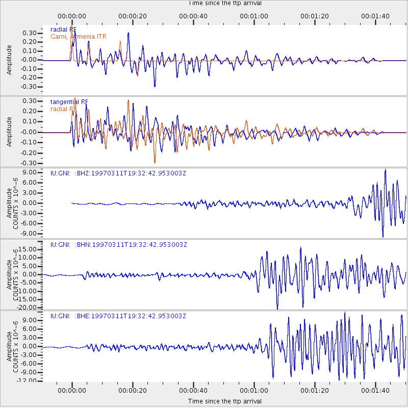
1997/03/11 (070) 19:21:23 GMT |
| Earthquake Depth: |
88 km |
| Earthquake Magnitude: |
5.7 MB |
| Earthquake Catalog/Contributor: |
WHDF/NEIC |
|
| Network: |
IU Global Seismograph Network (GSN - IRIS/USGS) |
| Station: |
GNI Garni, Armenia |
| Lat/Lon: |
40.15 N/44.74 E |
| Elevation: |
1609 m |
|
| Distance: |
78.4 deg |
| Az: |
309.276 deg |
| Baz: |
89.129 deg |
| Ray Param: |
0.049474213 |
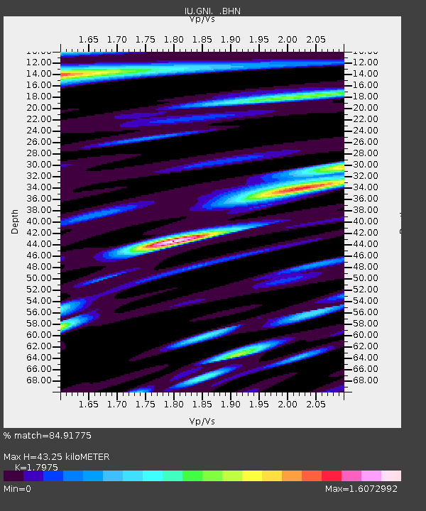
| Estimated Moho Depth: |
43.25 km |
| Estimated Crust Vp/Vs: |
1.80 |
| Assumed Crust Vp: |
6.291 km/s |
| Estimated Crust Vs: |
3.5 km/s |
| Estimated Crust Poisson's Ratio: |
0.28 |
|
| Radial Match: |
84.91775 % |
| Radial Bump: |
400 |
| Transverse Match: |
78.42715 % |
| Transverse Bump: |
400 |
| SOD ConfigId: |
4480 |
| Insert Time: |
2010-03-03 13:46:49.658 +0000 |
| GWidth: |
2.5 |
| Max Bumps: |
400 |
| Tol: |
0.001 |
|
Signal To Noise
| Channel | StoN | STA | LTA |
| IU:GNI: :BHN:19970311T19:32:42.953003Z | 4.5290885 | 8.54163E-7 | 1.885949E-7 |
| IU:GNI: :BHE:19970311T19:32:42.953003Z | 1.1822721 | 1.9204145E-7 | 1.6243422E-7 |
| IU:GNI: :BHZ:19970311T19:32:42.953003Z | 0.5989946 | 8.534925E-8 | 1.4248751E-7 |
| Arrivals |
| Ps | 5.6 SECOND |
| PpPs | 19 SECOND |
| PsPs/PpSs | 24 SECOND |


