You are here: Home > Network List > IU - Global Seismograph Network (GSN - IRIS/USGS) Stations List
> Station GNI Garni, Armenia > Earthquake Result Viewer
GNI Garni, Armenia - Earthquake Result Viewer
| Earthquake location: |
Mindanao, Philippines |
| Earthquake latitude/longitude: |
5.8/125.4 |
| Earthquake time(UTC): |
2008/12/25 (360) 03:20:29 GMT |
| Earthquake Depth: |
211 km |
| Earthquake Magnitude: |
6.1 MB, 6.3 MW, 6.3 MW |
| Earthquake Catalog/Contributor: |
WHDF/NEIC |
|
| Network: |
IU Global Seismograph Network (GSN - IRIS/USGS) |
| Station: |
GNI Garni, Armenia |
| Lat/Lon: |
40.15 N/44.74 E |
| Elevation: |
1609 m |
|
| Distance: |
79.2 deg |
| Az: |
309.643 deg |
| Baz: |
91.615 deg |
| Ray Param: |
0.04861816 |
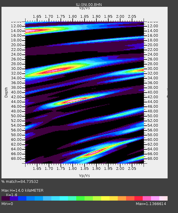
| Estimated Moho Depth: |
14.0 km |
| Estimated Crust Vp/Vs: |
1.60 |
| Assumed Crust Vp: |
6.291 km/s |
| Estimated Crust Vs: |
3.932 km/s |
| Estimated Crust Poisson's Ratio: |
0.18 |
|
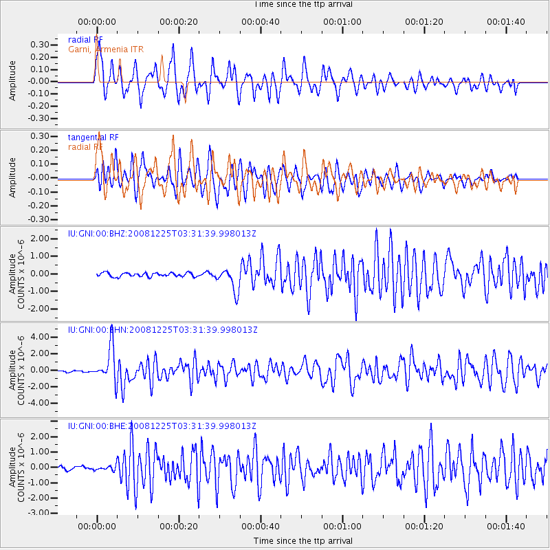
| Radial Match: |
84.73532 % |
| Radial Bump: |
400 |
| Transverse Match: |
64.69165 % |
| Transverse Bump: |
400 |
| SOD ConfigId: |
2658 |
| Insert Time: |
2010-03-03 13:46:52.957 +0000 |
| GWidth: |
2.5 |
| Max Bumps: |
400 |
| Tol: |
0.001 |
|
Signal To Noise
| Channel | StoN | STA | LTA |
| IU:GNI:00:BHN:20081225T03:31:39.998013Z | 28.521088 | 2.2024005E-6 | 7.722008E-8 |
| IU:GNI:00:BHE:20081225T03:31:39.998013Z | 1.2391458 | 1.701599E-7 | 1.3732033E-7 |
| IU:GNI:00:BHZ:20081225T03:31:39.998013Z | 6.3512053 | 6.9730123E-7 | 1.0979038E-7 |
| Arrivals |
| Ps | 1.4 SECOND |
| PpPs | 5.6 SECOND |
| PsPs/PpSs | 7.0 SECOND |


