You are here: Home > Network List > US - United States National Seismic Network Stations List
> Station AMTX Amarillo, Texas, USA > Earthquake Result Viewer
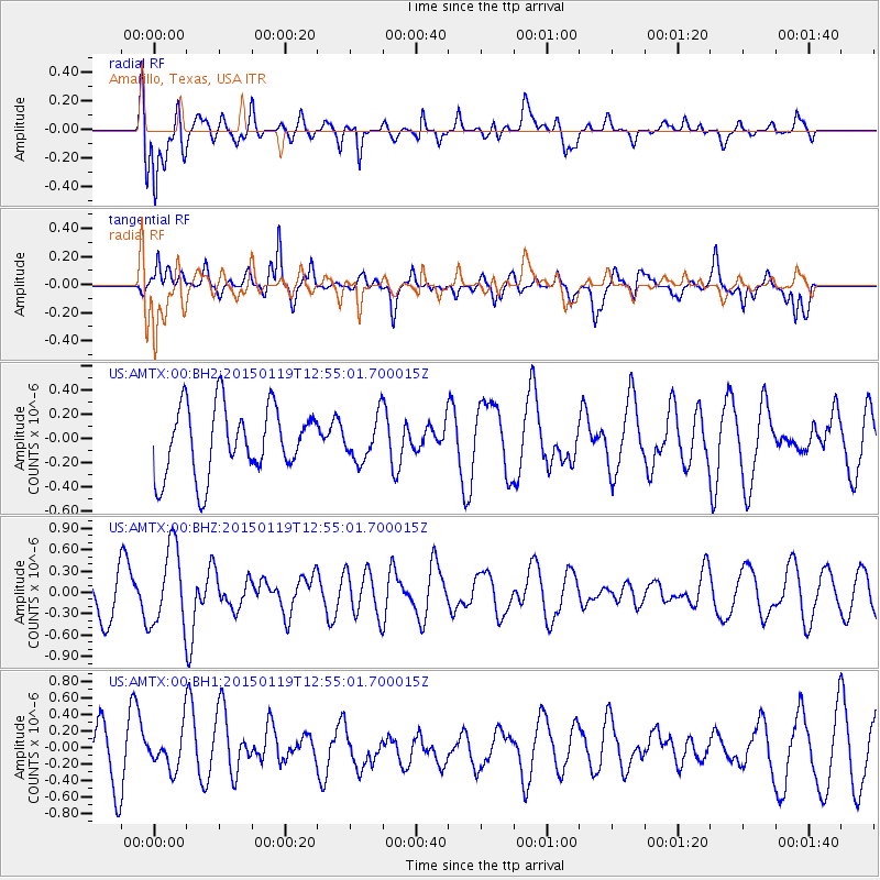
AMTX Amarillo, Texas, USA - Earthquake Result Viewer
*The percent match for this event was below the threshold and hence no stack was calculated.
| Earthquake location: |
Greenland Sea |
| Earthquake latitude/longitude: |
73.2/6.4 |
| Earthquake time(UTC): |
2015/01/19 (019) 12:45:13 GMT |
| Earthquake Depth: |
10 km |
| Earthquake Magnitude: |
5.5 MB |
| Earthquake Catalog/Contributor: |
NEIC PDE/NEIC COMCAT |
|
| Network: |
US United States National Seismic Network |
| Station: |
AMTX Amarillo, Texas, USA |
| Lat/Lon: |
34.53 N/101.41 W |
| Elevation: |
1010 m |
|
| Distance: |
62.2 deg |
| Az: |
297.321 deg |
| Baz: |
18.206 deg |
| Ray Param: |
$rayparam |
*The percent match for this event was below the threshold and hence was not used in the summary stack. |
|
| Radial Match: |
57.50686 % |
| Radial Bump: |
400 |
| Transverse Match: |
60.51753 % |
| Transverse Bump: |
400 |
| SOD ConfigId: |
837871 |
| Insert Time: |
2015-02-02 13:19:18.111 +0000 |
| GWidth: |
2.5 |
| Max Bumps: |
400 |
| Tol: |
0.001 |
|
Signal To Noise
| Channel | StoN | STA | LTA |
| US:AMTX:00:BHZ:20150119T12:55:01.700015Z | 2.3721642 | 5.5852416E-7 | 2.3544919E-7 |
| US:AMTX:00:BH1:20150119T12:55:01.700015Z | 0.872316 | 2.3413878E-7 | 2.684105E-7 |
| US:AMTX:00:BH2:20150119T12:55:01.700015Z | 0.8407332 | 2.1606927E-7 | 2.57001E-7 |
| Arrivals |
| Ps | |
| PpPs | |
| PsPs/PpSs | |


