You are here: Home > Network List > US - United States National Seismic Network Stations List
> Station CBKS Cedar Bluff, Kansas, USA > Earthquake Result Viewer
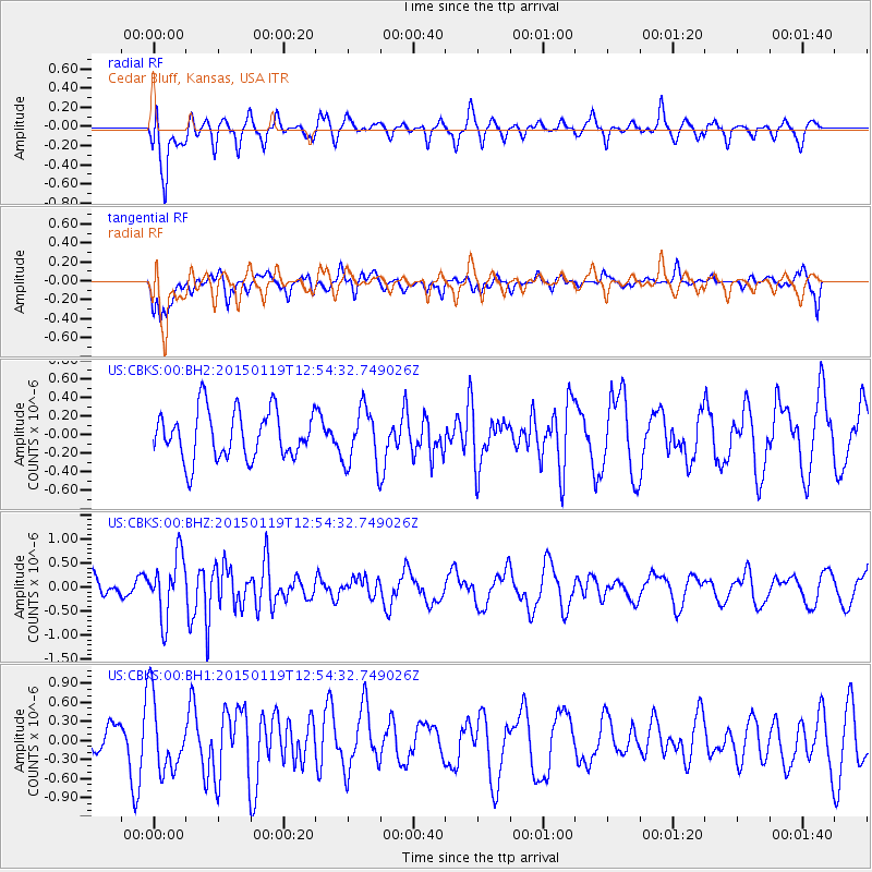
CBKS Cedar Bluff, Kansas, USA - Earthquake Result Viewer
*The percent match for this event was below the threshold and hence no stack was calculated.
| Earthquake location: |
Greenland Sea |
| Earthquake latitude/longitude: |
73.2/6.4 |
| Earthquake time(UTC): |
2015/01/19 (019) 12:45:13 GMT |
| Earthquake Depth: |
10 km |
| Earthquake Magnitude: |
5.5 MB |
| Earthquake Catalog/Contributor: |
NEIC PDE/NEIC COMCAT |
|
| Network: |
US United States National Seismic Network |
| Station: |
CBKS Cedar Bluff, Kansas, USA |
| Lat/Lon: |
38.81 N/99.74 W |
| Elevation: |
677 m |
|
| Distance: |
57.7 deg |
| Az: |
297.437 deg |
| Baz: |
19.258 deg |
| Ray Param: |
$rayparam |
*The percent match for this event was below the threshold and hence was not used in the summary stack. |
|
| Radial Match: |
66.47922 % |
| Radial Bump: |
400 |
| Transverse Match: |
53.522633 % |
| Transverse Bump: |
400 |
| SOD ConfigId: |
837871 |
| Insert Time: |
2015-02-02 13:19:24.294 +0000 |
| GWidth: |
2.5 |
| Max Bumps: |
400 |
| Tol: |
0.001 |
|
Signal To Noise
| Channel | StoN | STA | LTA |
| US:CBKS:00:BHZ:20150119T12:54:32.749026Z | 2.418297 | 6.307823E-7 | 2.608374E-7 |
| US:CBKS:00:BH1:20150119T12:54:32.749026Z | 1.8742436 | 5.7701135E-7 | 3.078636E-7 |
| US:CBKS:00:BH2:20150119T12:54:32.749026Z | 1.1926769 | 3.08204E-7 | 2.5841365E-7 |
| Arrivals |
| Ps | |
| PpPs | |
| PsPs/PpSs | |


